FT 2018 Day 1: Oasis Visitors Center (mile 0.0) to Campsite (mile 11.0)
11.0 FT miles
I was dropped of at the Oasis Visitors Center of Big Cypress National Preserve at 6am. It had already been an early morning. My Trail Angel and I had just driven up from our hotel in Key Largo. My Trail Angel had an early flight back to California which was the reason I was dropped off so early. I was thankful for the ride, since the Florida Trail's southern terminus isn't easy to get to.
Since it was dark and cold, I sought shelter in the Visitors Center’s dirty bathrooms. I guess I am getting back into “hiker trash" mode very quickly. As gross as the bathrooms were, the warmth was worth it.
When the sun finally rose, I exited my shelter and headed for the southern terminus monument. There was a mailbox with a trail register and backcountry permits for the preserve. It was a good thing that I had waited until it was light out to start, as I had totally missed the mailbox when I was exploring the area in the dark.
 |
| The southern terminus. |
I filled out my permit and started down a grassy area flanked by two fences. When I was walking around in the dark, I kept hearing splashes. That had made me nervous and I tried to convince myself that those splashes were not necessarily alligators.
I was wrong. As soon as I glanced towards the water a saw a large alligator. It admittedly made me nervous. The first part of the Florida Trail goes through almost 40 miles of cypress swamp. Because of Hurricane Irma, the water levels were still very high and there was going to be a considerable amount of wading through water in this first section.
 |
| The Oasis Visitors Center Welcome Gator. |
I passed the gator, vowing to be extra vigilant, and rounded the airfield that was next to the Visitors Center. I hadn't even gone one mile before I hit water. It was more of a flooded path than a pond, so I was able to temporarily put my gator fears aside.
 |
| The trail begins. |
The trail ended up being a mix of flooded path, muddy path, and dry path for the next several miles. I had originally imagined that I would be wading through water the entire day. This was much better.
 |
| The Florida Trail. |
 |
| Also, The Florida Trail. |
 |
| Still The Florida Trail. |
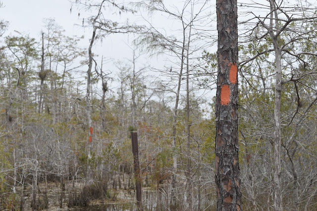
Several miles in I even got large stretches of dry trail. In these sections, the blazes came in handy as there wasn’t always a beaten path. Unlike the Pacific Crest Trail, the Florida Trail has regular blazes (orange painted stripes) marking the trail.
 |
| Follow the blazes. |
 |
| Double blazes indicating a turn. The higher blaze indicates the direction of the turn. Vlog Part 1 |
After stopping for lunch, I had only about 4 miles left to go until my intended camping spot for the night. It was during this stretch that the rain started. It was lightly raining/misting the rest of the day. This created kind of a gloomy atmosphere. It had been overcast all day because of the cold front moving through.
I slowly waded through more cypress swamp areas that were overrun with bomeliads, creating a Dr. Seuss like environment. It was really pretty, but I would have liked to see it on a sunny day to enjoy its full beauty.
 |
| Cypress swamp. |
 |
| Bromeliad. |
I finally made it to my tenting site around mid afternoon. I had to laugh because it was two single-tent sized dry spots in the middle of a soggy swamp. I took one of them as the next campsite was over 5 miles away.
I spent the rest of the afternoon sheltering from the rain, which picked up once the sun went down.
Vlog Part 2


Comments
Post a Comment