26.6 FT miles
I had meant to get up really early this morning. There were only two places in the St Marks National Wildlife Refuge where you could camp, and there was one that was supposedly one of the best, if not the best, campsite on the trail. However, it was over 26 miles away. Some of those miles were going to be road walks, so those parts would go quickly. On the other hand, if we encountered swampy areas, it might be a very long day.
A little before dawn I yelled over at Sugar Rush to see if she was awake, which she was. We packed up in the dark and, just like last night, went crashing through the brush trying to stay on trail. There were some parts that were clear and other parts that were not so clear.
When the sun came up, things didn't necessarily get better. We started to realize why we were having so much trouble last night. Even with daylight we couldn't always track the path on the ground and had to search as a team for hidden blazes.
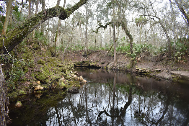
The river made it worth the effort. It was gorgeous despite being overcast. The river was another blackwater river that was flanked by palms, palmettos, mosses, and water-carved limestone banks.
 |
| The Aucilla River . |
 |
| River access. |
 |
| Another view of the river . |
The area surrounding the river was full of large, pretty, water-filled sinkholes. I'm pretty sure all the sinkholes and the river were connected underground. The sinkholes had the water-carved limestone banks as well and it was hard to not stop and admire each one.
 |
| A partially filled-in sinkhole. |
 |
| Another sinkhole. |
 |
| A particularly scenic sinkhole. |
 |
| Sinkhole pose. |
 |
| Limestone reflections. |
 |
| Sinkhole with lily pads. |
Unfortunately, all good things come to an end. We got to the junction that would start a 7.6 mile roadwalk to the next stretch. The name of that first road was Longsuffering Rd. Perfect. With as many roadwalks as this trail has, it could be a nickname for the Florida Trail itself.
 |
| I'm not joking. It was the name of the road. |
We took Longsuffering Road to a busy logging road that had constant traffic of logging trucks, along with the occasional personal vehicle. Then, we hit highway 98. After avoiding this type of road for so long, I got my hat blown off by passing trucks at least once.
Finally I reached JR’s Store. Sugar Rush had gone ahead of me to pick up her package. I had originally planned to send a resupply here, but for some reason had changed it to the town of St. Marks before I started the trail. While Sugar Rush was sorting through her box, I went in to get some snacks. I pretty much feasted on gas station fare. We stayed at the picnic table longer than I thought we would, and the swelling in my feet had gone down a lot by the time we got started again.
 |
| JR's Aucilla River Store . |
 |
| Signs on the door to JR's. Taxidermy and concealed weapons class. |
 |
| US 98. |
We walked two more miles down 98 until we entered Aucilla WMA again. Not far in we found flooded trail and ended up having to splash through. It was in this section that we encountered a southbound hiker named Mostly Harmless. He was doing the trail without the GPS app or detailed maps. I don't know how he has gotten as far as he has. Both Sugar Rush and I have had issues with the route, even with our GPS position in hand. We exchanged trail information for various sections, going into greater detail than usual to help Mostly Harmless out as best we could.
 |
| Yay. |
We walked more flooded trail until we hit the sign on the border of St. Marks National Wildlife Refuge. The sign gave a warning that we were about to walk “primitive trail.” It honestly didn't seem too bad. We have walked so much unmaintained trail so far that we might have a different definition of “primitive.” This trail actually had some boardwalks to cross.
 |
| St. Marks sign. |
 |
| Functional boardwalks! How is this "primitive?" |
Late in the day we came to a junction where the trail split off into the woods. There was also the option of following the jeep trail, which was the high water route alternative, in case the trail was flooded. We decided to try taking the official trail.
The official trail was swampy, but the worst part about it were the blazes. They were harder to follow than the ones near the Aucilla River. And, we were losing light. We crossed a jeep road and I checked if it connected with the high water route. Luckily it did and we ended up taking that route instead. The other alternative would have been a little too much adventure to do in the dark.
We took the high water route to where it rejoined the trail, then headed to our campsite that was in the middle of a series of canals. Part way through the canals I could smell the ocean breeze. The canals connected to the Gulf of Mexico and the water was brackish. It was a cool area to walk at night and Sugar Rush and I are excited to see it in the daylight tomorrow.
We set up our tents at the Ring Dike Campsite next to the water. There was a constant symphony of mullet jumping and splashing. I hung out in my tent while sugar rush made a phone call. Afterwards we ate dinner together on the benches. The sky started to clear and the stars came out. Some were even bright enough to reflect off the surface of the canals. Sugar Rush and I agreed that it was a good idea to push to that campsite for the night.


I'm still curious who Mostly Harmless was?
ReplyDeleteThat's the question. He died in 2018 and remains unidentified. This article is from July 2020
Deletehttps://lifeinnaples.net/magazinewp/2020/07/17/ccso-and-dna-lab-partner-in-attempt-to-id-hiker-mostly-harmless/
He was a hiker who started his trek on the Appalachian Trail in early 2017. From info gathered his first sighting on the trail was in NY. Sightings and hiker conversations with him along his trip South to GA tell the story of a man who had recently left a large IT company possibly in Brooklyn or NYC. He was a Screeps gaming enthusiast who had two notebooks of Screeps and other computer coding handwritten in it, with him when he was found. He spoke to other hikers about his love of sci-fi more particularly Dr. Who and Hitchhiker's Guide to the Galaxy. He also spoke of a father he had broke ties with because of abuse at a younger age and just an ex-girlfriend with no other info about her. Also possibly a sister in Sarasota FL. After GA sightings the next sightings of him are at the end or near the end of the Pinhoti Trail near GA FL state line. Next, near Crestview FL on the Florida Trail. There are substantiated sightings of him down to Big Cypress Preserve through June 2018. On July 23, 2018 he was found deceased in his tent at Nobles Campground at Ochopee FL in Collier County, FL. Autopsy shows starvation as a contributing factor even though he had food with him. He also had quality gear and $3600 in cash with him. To date identification of MH remains a mystery. If you would like a flyer with photos will be happy to send it.
DeleteNah they found and identified him. Watch the documentary. He was actually a pretty bad person, which was why nobody went looking for him.
ReplyDelete