Trail Day 35: Tentsite (mile 545.1) to Cameron Canyon Rd (mile 565.1)
20.0 PCT miles
Getting up this morning was really difficult. My body was still tired from yesterday. Even though the majority of what I walked was flat, it had been the most miles I have ever walked in a day. I had beaten my previous single day record by 5 miles. I should have gotten more rest, but I was being picked up from the trail today and I had a lot of miles still to go to get there. The high was also supposed to be 10 degrees (F) warmer than yesterday, so I wanted to get the majority of it done while the temperature was still cool. Therefore, I set my alarm for 4:30 am and was on the trail, climbing switchbacks with my tired legs by 5 am.
Even though getting up and getting my legs to work was difficult, watching the sunrise was very nice. I was climbing the side of the mountain facing the valley and the wind farm, so I was able to watch the landscape turn pink, and then slowly light up.
 |
| The wind farm at sunrise. |
 |
| The Mojave Desert at sunrise. |
 |
| Sunrise on the trail. |
I climbed the mountain for what seemed like forever. Even when it looked like I was close to the top, the trail would wind around another mountain face. By now, I had come to expect this from the trail. There seems to be a lot of unnecessary “touring.”
I was curious to see what was at the top of this mountain. While looking for places to camp last night I had considered a tentsite that was up there. It would have been a 30+ mile day, and I had enough daylight left yesterday to attempt it, but my body is glad I didn't. I considered it, however, because there was a note from a fellow hiker in the Guthook app about there being trail magic nearby.
I had eaten a lot of my food bag supply, and had to ration some items for today, so any kind of trail magic would have been great. I also was a little light on water because I needed to use some to cook dinner last night.
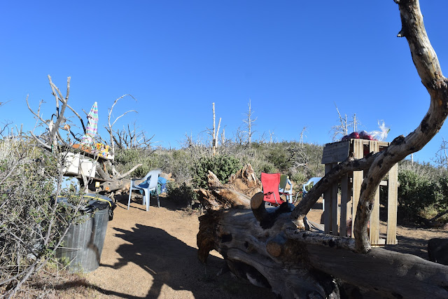
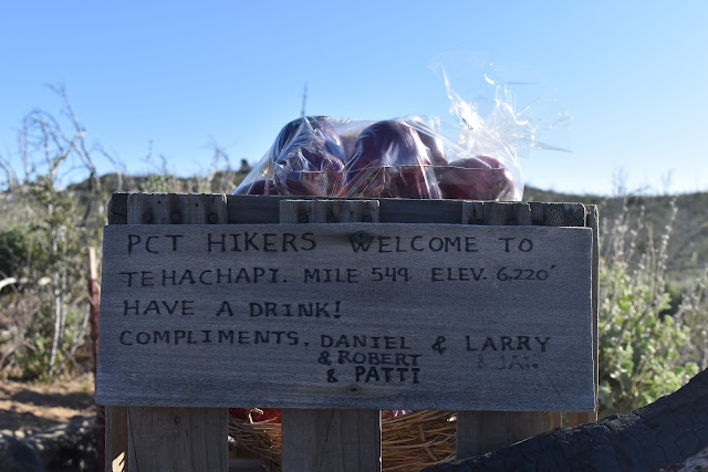
As I approached the mile that had the tentsite, I scanned the area for a cooler. Then, I saw it. It was way more than a cooler, it was an entire setup, complete with plastic chairs and collaspable camp chairs. There was plenty of fresh fruit and water (both individual bottles and gallon jugs), plus those cheap, brightly colored, artificially flavored sugar-water things that kids drink. Usually I would say “Eww” to that sort of thing, but after yesterday, I was in need of cheap calories.
 |
| Trail Magic. |
 |
| Sign from the trail angels who maintain the cache. |
 |
| Mmm, brightly colored sugar-water. |
Additionally, there was a trail register and a bucket labeled “Hiker Box.” I checked in the hiker box and found packets of sandwich cookies. I was really excited! I grabbed some cookies, some sugar-water, some regular water, a tangerine, and went to town on them. I did this while sitting in a camp chair (with cup holders!) facing a partial overlook of the valley below.
 |
| Cookies! |
 |
| Enjoying the view while filling up on magic. |
When I was done, I had a bit of a tummy-ache from all that sugar. At least it was better than the rumbling tummy that I constantly have when I do 20+ miles days. This trail magic cache is made all that more amazing by how remote it seemed to be. I only saw a single dirt road in the surrounding area, so I made a note in the trail register telling the trail angels how awesome they were.
I still had a lot of miles to do, so I reluctantly left the camp chair and started slowly heading down the mountain. Eventually I could see the next wind farm I was headed to, which was supposed to be an exceptionally large one.
 |
| My first glimpse of the next wind farm. |
As I headed down, I was once again walking through an area that had been on fire at some point. This area was a little different in that all the burned trees were also toppled over. Some were clearly cut down, but others had snapped at the base of the trunk or had fallen over whole, roots and all. All this meant I was without shade for several miles again.
 |
| Dead, burned trees. |
As I was nearing the bottom of the mountain, I started to run into quite a few day hikers. I had forgotten it was the weekend. At least I got a passing greeting of “Good for you!,” meaning they understood what I was doing. I was really dirty and hasn't washed my clothes in 6 days.
 |
| Approaching the wind farm. |
 |
| Joshua trees and wind turbines. |
Close to the bottom, I grabbed the first bit of shade I could find. I had gone about 12 miles already and my feet were hurting from the swelling. It wasn't ideal, since the ground was really sloped in this area, but it was shade. I took my shoes and socks off to let my feet dry/breathe and ate lunch. Despite the earlier trail magic, I could have eaten the rest of the food in my food bag at that point. I had to save some food for the afternoon because I still had 8-9 miles to go.
 |
| Finally some shade! |
I put my shoes on and headed down to the bottom where the trail evened out. There were two large trees on flat ground, providing plenty of shade. Of course. That would have made such a better picnic area.
I kept going and hit another trail register. Further south along the trail the registers had been pretty sporadic. This week they seem to have gotten more regular, with permanent boxes for them along the trail. It is kind of fun to look back and see where people I had met were on the trail. Some were only a day ahead of me, others were at least a week in front now. With all the luxury zero days I have been able to take as a SoCal resident, most of the people hiking around me started 3 weeks after I did.
After the trail register, I headed to the Tehachapi-Willow Springs Rd crossing. This is where most people hitchhike into Tehachapi from, considering it is easier and safer than Highway 58. I was headed to the frontage road by 58 today because it was a prearranged pick up spot with my Trail Angel. I was curious about a water cache at the road crossing. If there was still water left, I was going to grab some.
As I hit the parking lot by the road crossing, I noticed some gallon jugs, and they still had water in them. As I approached the cache, I noticed the jeep parked next to it that had a large garbage bag hanging from its back gate. Large garbage bags usually indicate trail magic, since hikers have/make a lot of trash. I approached closer and noticed some benches and a grill, but no other hikers.
I timidly asked the two people lounging there if they were doing trail magic. They were! They were two trail angels named Steven and Michelle, and they had set up to offer breakfast and lunch to thru-hikers.
I was offered a seat and a freshly grilled brat. They also had coolers full of soda, water, beer, cans of Grape-a-Rita, and string cheese. Additionally they had fresh fruit. I had already eaten lunch, but I was totally OK with a second lunch. While I was sitting there several other hikers trickled in, some from the trail, some returning to the trail from rides they had gotten from Tehachapi.
 |
| Trail magic! |
As I was finishing up, the one hiker I had been waiting for arrived, Achilles. We were in the middle of a wind farm and he had either studied or done a thesis (I forget which) on wind turbine blades as an engineering student. He was happy to point out the different models of wind turbines, including ones that probably went back to the 60s.
I could have hung out at the trail magic for longer, but I still had about 8 more miles to go, so I headed out. Wheras I was dragging before the trail magic, I was energized after it. It was a good thing too because I was headed uphill again.
 |
| Heading up. |
I headed through the rolling hills of the wind farm, then briefly through the edge of farm property (complete with lounging cows), and back through the wind farm. To brighten my mood even more, there were quite a few bright poppies blooming. It seemed late in the season for poppies as the other superblooms had already wilted this year.
 |
| Danger. |
 |
| Mooooooo. |
 |
| Poppies! |
 |
| Wildflowers and wind turbines. |
And, after listening to Achilles talk about them, I was able to entertain myself my looking at the different models of wind turbines as I walked through the field, trying to guess in what decade they were made based on their design and logo. One observation I made was that the newer generations of turbines are much quieter. Those old, clunky ones made quite a bit of racket.
 |
| Lattice turbines. |
 |
| Noisy, old turbines next to sleeker, newer models. |
 |
| Neg-Migon. |
 |
| Vestas. |
By the time I had crested the hill 5 miles later, the energy from the trail magic was wearing off and it was pretty hot. I rested in the shade with another hiker named Loner (4th hiking kilt sighting). I texted back in forth with my Trail Angel for a bit, who was already waiting for me at the bottom of the switchbacks.
Having sufficiently cooled down, I started heading down the switchbacks. I was actually able to see my Trail Angel’s car right away. He had parked further down the frontage road than I expected, saving me a mile of walking today. It meant I would have to tack the mile on at the beginning of the next week, but I was OK with that at the moment.
 |
| The view of Highway 58 from the switchbacks. My next trail day will start with a long climb up those mountains. |
My Trail Angel had walked up part of the switchbacks with a small cooler that had some water and Gatorade that we shared with Loner. Then we headed back to the car to head home and eat a lot of food.


Comments
Post a Comment