Formerly Susanne's PCT Journal. This is a simple trail journal of my long distance thru-hiking adventures/misadventures. Family, friends, and total strangers are welcome to come along for the journey!
-Susanne aka "Snapper"
Get link
Facebook
X
Pinterest
Email
Other Apps
FT2018 Day 43: Fellowship Rd (mile 712.6) to campsite near Aucilla River (mile 734.2)
21.6 FT miles
I had originally planned to get up early. I was too comfortable at Belinda's house, so I ended up sleeping in a while. Sugar Rush did the same.
When we finally got up, Belinda made us delicious omelettes. We took our time eating breakfast a and chatting before Belinda drove us back to the trail. We said goodbye, thanking her for being so amazing, then started in on the rest of that awful road walk.
We would be road walking all day again. We were a little happier about it since we were walking on dirt road and not pavement. Then, we hit a paved road. We alternated between dirt and paved road most of the day.
Bear tracks on one of the dirt roads .
One of the paved roads. It kind of looks like the other paved roads.
An abandoned home looking very much like a horror movie set.
As neared the intersection of two roads, we stumbled upon something that broke up the monotony. There was a Pepsi vending machine along one of the dirt roads. At first I thought it was an abandoned machine. However, it was humming and the lights were on. It said it took $0.75, so I thought I would try it. Unbelievably, it spat out a cold can of soda. It was an off-brand lemon-lime soda, and not the Sierra Mist we had selected, but it was still amazing that it worked.
"Is that a Pepsi machine?"- Sugar Rush
Vending success!
Since we got a very late start to hiking, we hiked until 2 pm before taking our lunch. We had decided that we were going to stop at a church. This time, no one was at the church itself. We found some picnic tables on the back and ate lunch there.
Lunch at the church.
We walked until we encountered a graveyard and decided to look inside. It was a pretty old cemetery with graves from the early 1900s, including a couple of Confederate soldiers, complete with fresh Confedarate flags by their grave stones. There were some very worn limestone headstones that looked like the names were engraved by non-professional hands.
Old headstones.
Confederate headstone .
Limestone headstone.
The rest of the afternoon was spent chipping away at the road walk. The monotony was really starting to take over and our conversations had pretty much disappeared. We ended up putting headphones in to try to grind out those last few miles.
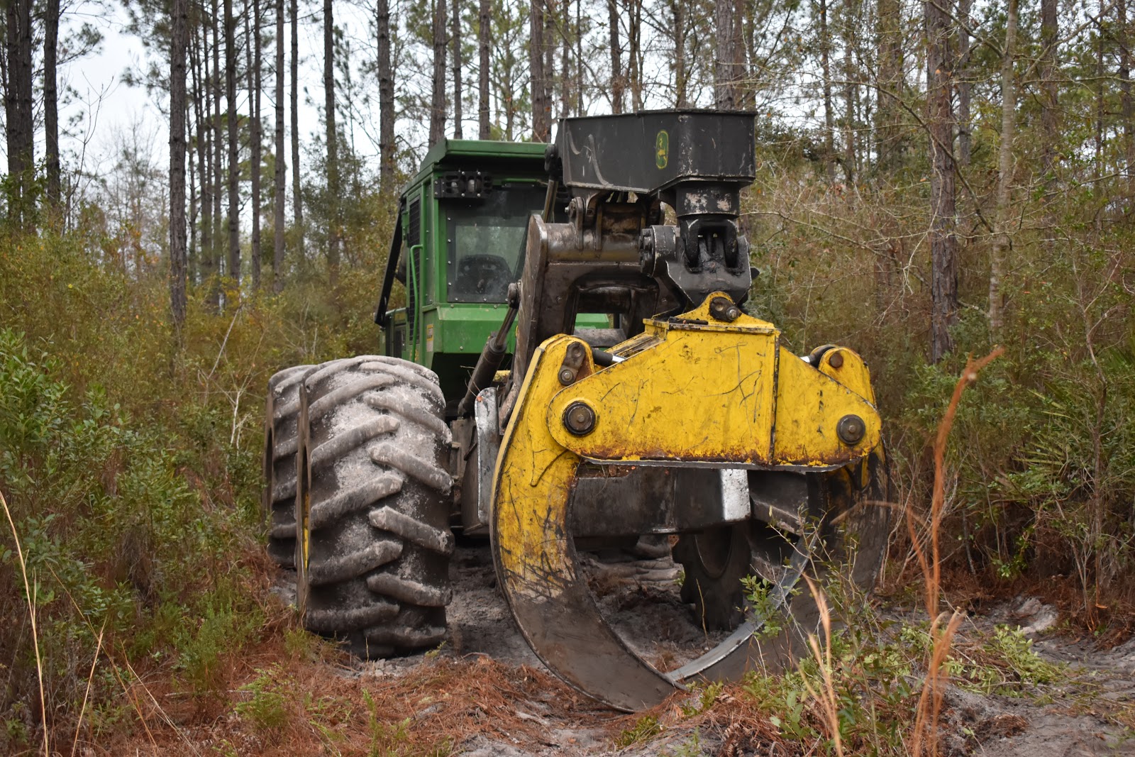
After passing a turn, then walking by some logging equipment, we made it to Aucilla WMA as it was getting dark out. Soon after we entered we were at least able to see the river, something that we weren't sure would happen, given how late in the day it was.
Menacing looking logging equipment.
More logging equipment .
Vlog
We took a short break and then went forward in the dark. Sugar Rush was in the lead. She regularly hikes until 8/8:30 pm every day anyway. I haven't been comfortable doing too much night hiking on this trail since it can be difficult to follow.
This section was definitely one that was not friendly to night hiking. At least there were two of us with two with two GPSs to figure things out. Even so, it was pretty frustrating. We did about 3 miles into the WMA, then stopped at a spot labeled “random camping" on the app. It wasn't a particularly good site, but we made it work. We also agreed to get up early in the morning tomorrow as the campsite we wanted to get to was over 26 miles away.
20.3 miles Just like the past few mornings, it was difficult to get up again. Unlike the past few mornings, I could actually see snow on top of my tent. It was supposed to rain or snow on and off the majority of the day again. That was not a motivating thought to get me out of my sleeping bag. I had also finally used the hand warmers that I had purchased back in Flagstaff, and they were still warm inside my bag. Somehow, I emerged from that bag and packed everything up one last time. I was only about 20 miles from the Utah border and on schedule to finish the trail today. Most of the items I had on me were damp or wet. It didn’t bother me packing them up as I knew I would be warm and dry tonight. What did bother me was having to put on my wet, cold, dirty shoes. After I did that, I had wet, cold, dirty socks as well. In Flagstaff I had also picked up toe warmers, so I stuck those inside my shoes and hoped that they would help. The view looking out of my tent. My camps...
26.6 FT miles I had meant to get up really early this morning. There were only two places in the St Marks National Wildlife Refuge where you could camp, and there was one that was supposedly one of the best, if not the best, campsite on the trail. However, it was over 26 miles away. Some of those miles were going to be road walks, so those parts would go quickly. On the other hand, if we encountered swampy areas, it might be a very long day. A little before dawn I yelled over at Sugar Rush to see if she was awake, which she was. We packed up in the dark and, just like last night, went crashing through the brush trying to stay on trail. There were some parts that were clear and other parts that were not so clear. When the sun came up, things didn't necessarily get better. We started to realize why we were having so much trouble last night. Even with daylight we couldn't always track the path on the ground and had to search as a team for hidden blazes. The river made...
27.1 miles I tried looking at what the day had in store for my on the Arizona Trail app. Pretty much the only things labeled were forest roads, trail junctions, and stock tanks. Nothing too exciting. The morning turned out mostly as described. I left the tank I camped at last night on a forest road, then joined another forest road, then a footpath for a short while, then another forest road. Hiking a forest road. The signs could have been a little better in this section. I had to keep looking at my app to make sure I knew where to turn. After a while the signage got better and I turned onto another footpath. A footpath section of trail. I was heading to a spring I wanted to use as a water source. When I checked the app, it showed me off trail. I knew I couldn't have been off trail because I turned at a very clear “Arizona Trail” sign. On the app, the trail followed forest roads. I figured the footpath must be new and the app hadn't been updated...


Comments
Post a Comment