Trail Day 12: Tahquitz Peak Trail Junction (mile 178.0) to tentsite (mile 182.7)
4.7 PCT miles plus, 2.5 mile side trail and 6 miles of backtracking
Today was supposed to be the day I cleared the Mt San Jacinto area, including the steep and snowy Fuller Ridge. I wanted to pick up right where the fire closure ended, but the Tahquitz Peak trail from Idyllwild was still iced over and very treacherous, requiring expert skill with an ice axe and crampons to get through.
After talking to the rangers in Idyllwild yesterday I decided to take a different trail, the Devils Slide trail to meet up with the PCT. Devils Slide intersects with the trail about 1.4 miles down the PCT from where the fire closure technically ends.
From talking to the instructors in the mountaineering classes I recently took, the real keys to mountaineering are not necessarily the snow travel skills themselves. It is the preparation, risk assessment, and ability to "turn around" if necessary. From my perspective I was practicing good mountaineering. There was no need for the extra risk on the Tahquitz Trail. However, in order to appease the "cool kid" voices in my head, I was going to backtrack the 1.4 miles from Saddle Junction to the end of the fire closure at the Tahquitz Trail junction, and start the PCT from there.
I had a rough time getting up this morning. I was up until 1 am last night repacking and resupplying my bag. I only got about 3 hours sleep, and yet still ended up leaving for Idyllwild later than originally planned. Luckily I was able to sleep during part of my ride to the trailhead.
My Trail Angel dropped me off at the trailhead for the Devils Slide trail and I started heading up. On the way up I passed some day hikers, despite wearing a full pack. Maybe it is the thru-hiker snobbishness starting to appear, but it felt good to pass them. It meant that despite my struggles from a couple days ago, the conditioning is kicking in.
 |
| Devils Slide trailhead |
 |
| Devils Slide trail gaining in elevation (and getting pretty) |
 |
| The view as you ascend Devils Slide. |
This is a day I figured I would enjoy since I love coming up to San Jacinto. I usually come up the other side of the mountain via the Palm Springs Tramway, but this side is just as pretty. It has large, quiet pine forests with birds chirping and squirrels running around everywhere. As soon as I hit the saddle I was greeted by a beautiful woodpecker. Unfortunately I could not get a good picture.
 |
| I swear, this blurry thing is a woodpecker! |
 |
| Saddle Junction. |
I headed through the pine forest towards the junction with the Tahquitz Peak Trail and soon hit some snow. It wasn't bad, but I still put my microspikes on for security. The path was pretty well cut by footprints, but occasionally I had to pull out my GPS app to make sure I was on the correct route. I found the junction and headed back.
 |
| Hitting the snow on the way to the junction with Tahquitz Peak Trail. |
 |
| I've already hiked about 4 miles to get to the "start" of my PCT miles for the day. |
 |
| The view from the junction of the PCT and Tahquitz Peak Trail (where the PCT resumes from the Mountain Fire Closure). |
I passed the saddle again and headed up quite a bit in elevation. Eventually I hit snow again and put on my microspikes. Travel through the snow was very slow, so I was relieved that the PCT eventually veered off from the trail that goes to the peak and became snowless for a couple miles.
 |
| This is much easier to walk on. |
Even though there wasn't snow there were some extremely spiky and painful plants along the way with long, sharp thorns. There were times when I had to choose to brush up against a manzanita trees or the thorny bush and I chose to hug the manzanita every time.
 |
| I don't know what this plant is but I hate it. |
 |
| The view looking back towards Tahquitz Peak. |
The trail then headed steeply downhill, which I would have been OK with if it didn't just immediately head back uphill after the junction with a trail. That was pretty dumb. I did get to see dear along the way though. That was pretty cool.
 |
| Hello, dear. |
There were also plenty of water sources available from the snowmelt. Unfortunately they all had a bad taste, even after going through my water filter. I couldn't quite figure out if it was a taste of dirt, algae, or decomposing pine needles but it was enough for me to skip filling up my water bottles and wait for a better source located near Fuller Ridge.
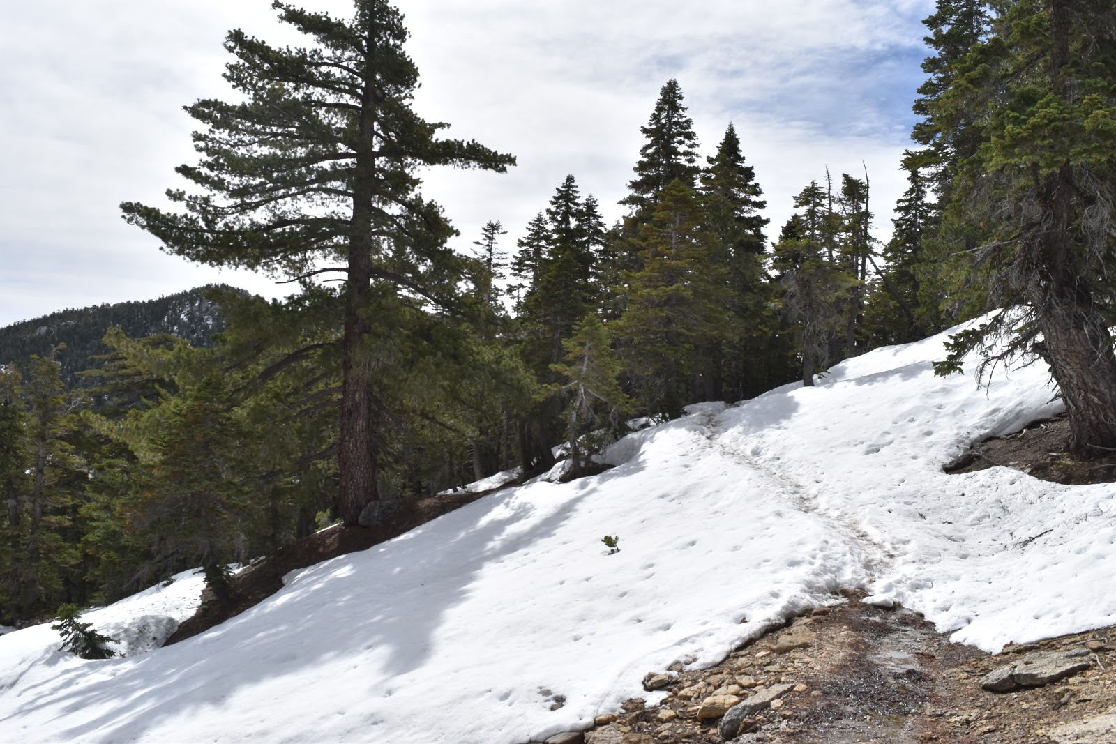
Everything was going well until I hit where the snow started getting abundant again. I wasn't expecting to have to carefully navigate snow until about mile 187, but I had to put on my microspikes a little before mile 185.
For the most part, there was an easy path of footprints to follow. However, it was well into the afternoon and the snow was soft so I had to worry about postholing, where your foot punches deeply through the snow. The problem here wasn't just that the snow was soft because of the time of day, but also because the footprint trail through the snow did not always follow the dirt trail underneath it.
While the footprint path was always close to the actual trail, which was starting to appear from the melt, sometimes it was slightly offset from the trail. This meant that the footprint path was sometimes above logs and boulders instead of the dirt path. Plants and rocks absorb light energy from the sun which melts the snow around it. So if you walk on top of it, it was likely that you were going to posthole. And, postholing into a buried boulder is a great way to get injured.
 |
| The footprint trail slightly offset (bottom right) from the emerging trail (top left). |
 |
| Someone else's posthole next to a couple boulders. Not visible is another boulder at the bottom of the posthole. |
It was taking a long time to gradually work my way over the trail with minimal postholing, and when I checked to time around mile 185, it was already after 3:30 pm. I knew from the trail conditions that there was at least 3 miles of snow across Fuller Ridge, starting at mile 187.
I could not guarantee to myself that, with the slow progress I was making through the snow, I would be able to cross Fuller Ridge with good daylight. I made a mountaineering decision and thought that it would be smarter to attempt Fuller Ridge in the morning.
The problem was two-fold. First, at mile 185.4 I was too far into the snow filled area to pitch a tent on soil. Second, I was in an area run by the state park (and not the national forest) and camping was only allowed in designated areas with a special permit. I was neither in a designated area nor had a permit. Originally I thought I would be out of the state park by the time I had to camp to tonight, but the park lines ended 3 more miles from my location, and there was probably snow there too.
I checked both my Guthook app and my Halfmile paper maps for the closest place to camp. I had to backtrack over 2 miles. That was going to hurt both my legs and my pride, but I felt like it was the best solution given how late in the day it was.
I started backtracking over the snow and felt relieved when I cleared it. Soon after I bumped into the first thru-hiker I had seen all day. I was starting to believe that I was the only idiot out there. His name was Orange Crush and he was a "cool kid." I told him about the conditions and my decision, but he said he has walked too far already today to turn around so he kept going, hitting the snow area after 4 pm. I wished him luck. He would probably be fine. He seemed like a one of those people who are a combination of surfer and daredevil. I was not either of these things.
I passed another "cool kid" on my backtrack of shame back to the national forest boundary and filled up a couple bottles of that bad tasting water along the way, since now I had no other water choices. I headed back to mile 182.7 where there would be campsites. I got even more annoyed when I found out I had to walk a large portion of it back uphill.
Just to make me feel even more guilty about my decision, I had mostly been walking through sheltered pine forest, which didn't even have much of a breeze, but the area marked as having campsites was overlooking the valley where Idyllwild is located. That valley was experiencing incredible clouds and high winds.
 |
| Scary looking clouds rolling in over Idyllwild. |
I set my stuff down and walked around the area looking for the best location where I could set up my tent away from the wind. Eventually I found a spot behind some trees that seemed to be breaking the majority of it up. However, it was still really noisy and cold, and the wind occasionally gusted so strongly that it rocked my tent through the wind break. Damn. I have a big day tomorrow crossing the snow areas and was hoping to get some good sleep. Oh well.
 |
| Calm with the occasional gust. |


Comments
Post a Comment