Trail Day 10: Tentsite (mile 154.5) to Fobes Ranch Junction (mile 166.6), plus detour to highway 74
12.1 PCT miles, plus 5.4 miles of detour
I woke up this morning and tried to come up with a plan. Today I was going to hit the point where the PCT is closed because of fire damage, which was a little over 12 miles away. The detour route was mainly a road walk and didn't have very many places to camp since it wasn't designed to be part of the PCT.
One option was that I could do a short day, camping as close to the closure as possible, then do the entire detour the next day. The other was that I could walk to the nearest campground at Lake Hemet, which I estimated to be about 18-something miles away, then do a short day into Idyllwild after that.
I was leaning towards the second option, but camping at Lake Hemet was fairly expensive (for PCT camping). I would also be waiting in Idyllwild for my Trail Angel to pick me up for a long time, since I planned to zero at home again.
From the last couple days of hiking, I could tell that my body needed to rest. This second week was so much more of a struggle than the first week. Last week I could do 20 mile days. This week I was struggling to even make it to 17/18 miles. My legs, feet, and ankles were swollen. My back was getting frustrated with my pack. I think it all boils down to the fact that even though I trained fairly long miles with a heavier backpack, I have never hiked for this long. My training trips were all 2-3 days. I think it is all catching up to me.
I decided to text my Trail Angel and see if there was any chance he could get off work early to come pick me up at a reasonable time. It was 6:30 am and somehow he was awake. He said he would start getting ready to go into work then which meant he could come get me. Yay! My new plan was to do the PCT up until the closure, take the detour down to the road, and do as much if the road walk as I could before being picked up for a couple zero days at home. After my zero days I would be dropped off at the trailhead to rejoin the PCT after the fire closure section. I didn't think skipping a couple miles of road walk detour was going to ruin my PCT experience. Finally having a plan for the day, I packed up camp and started on my way.
Most people at the Paradise Valley Cafe were planning to skip this section, because it was so close to the detour . There was even a trail angel giving rides between locations for $5 to help cover gas. Those people were missing out. This section was gaining in elevation on the approach to San Jacinto so it was going through spectacular mountain terrain with pine trees and large granite boulders. The trail itself was constantly trading off between dirt path and large granite slab.
 |
| Look what people you people are missing! |
 |
| Just look! |
Not soon after I had set out, I bumped into two hikers I had seen yesterday at the cafe named Elinor and Daniel. They had started out solo but had teamed up just before Scissors Crossing.
I've noticed that most of the solo hikers I had seen at the beginning have formed teams by now. Not me though. I haven't really bumped into anyone who keeps the same schedule or who hikes at the same pace as I do. I am also missing out on the social downtime by spending my zeros at home. I wouldn't change that though. Zeros at home are free, there is also a nice bed, a TV, and a hot tub.
I joked with Elinor and Daniel that they would be my leapfrog buddies for the day, which we did for a while. However, after a steep uphill section they zoomed ahead and I didn't see them again. So much for leapfrog buddies.
Because the trail was at about 6,000 ft, which seems to be a vegetation transition zone, it eventually started to alternate between pine forest and shrub trees, depending on if I was on the coastal facing or desert facing side of the mountain.
Eventually I got to a junction for a couple different springs. One was a mile off trail (and had a sign), the other was .3 miles off trail (and did not have a sign). I looked in the direction of the .3 mile spring and there was kind of what looked to be a steep path downhill, but I did not like the idea of climbing back up that incline, especially if there ended up not being a spring down there. I checked my water supply and guessed that I could make it the rest of the way to the closure, where I would run into water fairly early on the detour. It would be cutting it close but I thought I could make it.
I continued on and started climbing up and up the mountain. I was going to top out at 7,100 ft today so there was a lot of climbing to do. It was on the desert facing side to so there wasn't a lot of shade. I got pretty hot and tired, so when I saw my first shaded pine tree spot I stopped and grabbed it. There was a flat, pine needle spot right at the base of the pine tree. I plopped straight down and reached in my bag for a snack.
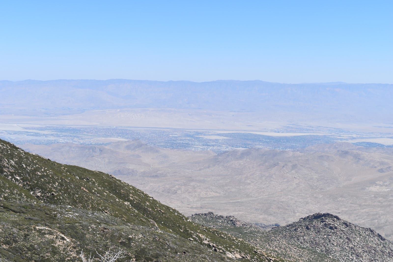 |
| View of palm desert to the east.. |
 |
| Lake Hemet to the west. |
As I got my snack out I felt something biting or poking me. I looked down and saw my entire right pant leg covered in red/black ants! I jumped up, jumped up and down, and brushed them off as quickly and thoroughly as possible. I'm not sure if I had ants in my pants, but I certainly had ants on my pants. I looked back at what appeared to be a perfect sitting spot and saw an ant mound teeming with ants right next to the base of the tree. I brushed them off me and my gear as best I could and then continued on the trail.
After I started hitting the mountain crests, I felt the need to stop and take my shoes off due to the swelling in my feet. There was no shade, but on the crest the breeze was nice and cool. I found a set of rocks that I could lounge on. Literally. The was one flat rock at a perfect incline to lay back, a flat spot for my bum, and another rock to prop my feet up on. It was incredibly comfortable. I didn't have a care in the world until I heard a noise behind me.
 |
| Walking the mountain crest. Mt. San Jacinto in the background. |
 |
| Walking the mountain crest. |
It was a man leading a horse. I had actually seen this man just outside Barrel Springs as well. He is attempting to do the entire trail with his 2 horses, who he alternates riding each day. His wife takes care of the off trail base, making sure the other horse is fed, and meets him at the next location. That must be so much work! It is hard enough for me to plan food and water for myself, much less a horse as well.
After he left I checked my water. I had about a liter left and 5 miles to the closure. That wasn't good. I started drinking sparingly as I continued on the trail.
By now I was really high in elevation and walking over the mountain crests like waves. On each wave I would get a closer view of Mt San Jacinto and its snow. It was too bad I would have to go back down in elevation because it really felt like I was making progress towards the "big" mountain.
 |
| Mt. San Jacinto. Getting closer! |
 |
| Bonus wildflowers |
 |
| Bonus beetle. |
I don't know if it was because of the elevation or because my body was tired, but going uphill to each crest was harder than it should have been. Eventually I reached a nice pine forest area and started heading down. It was a pretty steep downhill portion so it was slow going as well. It had been hours since I had seen my supposed leapfrog buddies for the day so I just imagined that they had hopped down this section like billy goats several hours before me.
 |
| Pine trees. |
 |
| The trail leading through the pine forest. |
By this time I was running really low on water. I tried to go down the steep switchbacks as fast as I safely could. Finally, I reached the closure sign and started down another set of switchbacks to get to the junction with Fobes Ranch Road.
 |
| End of the line. |
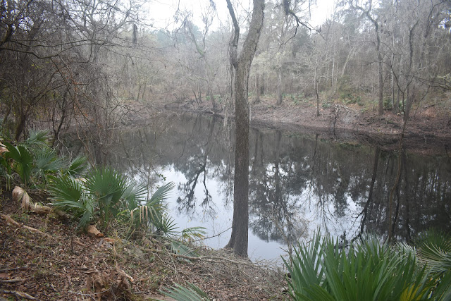
It was only a mile and a half to the first water source on the detour, but on the trail a mile and a half can seem really long. I was now much lower in elevation and it was really hot and dry. I was starting to get a little panicky.
The first moment I saw the stream I threw off my pack, grabbed my water filter bag, and started filtering/drinking water. Eventually I moved to a spot with more flow (and a bit of a cascade) to fill my water stores. By that time it was well after 4 pm and I still had to at least get to highway 74 in order to be picked up.
 |
| WATER! |
I hit the junction of Fobes Ranch Trail and Fobes Ranch Road and checked the mileage on my Guthook app. That is when I noticed the mileage listed on the detour didn't include the trail I had just used to come down the mountain. The road was 5.4 miles away from the PCT, not 3.5. It also meant that Lake Hemet was at least two miles further from the start of the detour than I had thought.
Since it was late in the day, and my legs, ankles, and feet were painfully swollen, the junction of Forbes Ranch Road and highway 74 was going to be my stopping point. I gritted it out, pressing the custom “come get me” message button on my SPOT a half mile out, and then again at the junction of the two roads. I sat down and leaned against the fence. With the way my feet were swollen, I had to prop them up on my bag. There would be no more walking for me today.
At the highway, I finally had good cell reception, so I texted my Trail Angel about my new meeting point, thinking he got into/left work early and was already in the area. I got a text back that he was having car trouble and needed to go home to use my car to come get me. That was a problem. At that time of day that is a two hour drive, and he wasn't even at the house yet. With my level of exhaustion and pain, combined with the shock that he wasn't in the area like I thought, it was pretty upsetting. I was absolutely done walking for the day, so I was resigned to waiting on the side of a cold mountain road in the dark for hours again.
I played around on my phone for a bit before I heard voices behind me. Clearly I was going to have to explain my shame to my fellow hikers. To my surprise, it was Elinor and Daniel. Somehow I had past them as they were going to a water source (the one I decided to skip). Part of me was relieved to see that they were as shattered from the day’s hike as I was.
They were going to hitch a ride into town and offered for me to come to Idyllwild while I waited. Not about to get up, I told them if their ride had enough space I would take them up on the offer.
Daniel mentioned that there was a car coming, so Elinor stuck her thumb out, and the car stopped. The first car actually pulled over! Everyone who heard the story claimed it was because of Elinor’s hiking skirt, but it was just sheer luck. The man who pulled over (in a roomy SUV) was a local named BJ who was headed into Idyllwild for pizza. Since he lives in the area, he says he tries to give rides to a couple sets of hikers every hiking season. Such a nice guy!
We arrived in Idyllwild, Elinor got her room in town, and then we all ate huge meals at the Lumber Mill Grill and Bar. By the time we finished it was after 9 pm. We headed back to the lodge and Elinor and Daniel waited with me on the gazebo swings outside Silver Pines Village until my Trail Angel showed up at 10 pm. Elinor and Daniel are good people.


Yay for Eleanor and David! It's so awesome to read about the friendly people you keep meeting.
ReplyDeleteThere are good people in the world. It is sad that sometimes it takes going into the wilderness to find them.
Delete