18.4 PCT miles plus .4 miles round trip to the spring
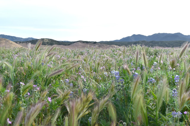
My Trail Angel dropped me off where he had picked me up a day and a half ago, at Monetzuma Rd just past Barrel Springs. After climbing the hills for a little bit the trail dumped out into a large grassy meadow. The grasses were starting to brown, but there were tiny purple flowers poking out of the grass as well. Pretty soon more flowers started to emerge in yellows, purples and oranges. I even got to see my favorite California wildflower, poppies! The looked like they were starting to die, but it was still cool to see them.
 |
| Wildflowers and grasses in the meadow. |
The trail alternated for a time between grassy meadow and large shady trees. Where were these trees the other day?
 |
| PCT hikers walking the meadow just past Montezuma Rd. |
Eventually the trail lead to another PCT landmark, Eagle Rock. It is just what it sounds like, a rock outcropping in the meadow shaped like an eagle. There were a couple thru-hikers there admiring it when I arrived. I took a couple pictures of it, including one with me sitting on the eagle's shoulder, then continued on my way.
 |
| Riding the shoulder of my very own giant eagle. |
There was another rattlesnake encounter (#2 for the trip so far), with the snake being triggered by a hiker in front of me. By the time I got there it was rattling and in its defensive coil in the bushes. Luckily, this path was pretty wide so we were able to go around it pretty easily. It actually drew a crowd of admirers and eventually stopped rattling as snake and people watched each other from opposite sides of the path.
 |
| The trail leading away from Eagle Rock. |
 |
| Patches of poppies! |
 |
| Oak trees providing some shade along the trail. |
Eventually the trail lead into the town of Warner Springs. This is where most people choose the spend a rest day or two. It is also a main resupply town, where people can get their food resupply boxes.
When I got to the Community Center it was swarming with people. There was music blasting from the pop-up gear store in the parking area and tents everywhere. People were chatting in groups. I was caught off guard by just how many people were there, talking in their own social circles. As someone who has struggled with social anxiety, it was a bit overwhelming. I ended up just using the nice, clean bathroom facilities and headed out fairly quickly. As I was heading out I saw that someone had left some Easter eggs with candy for PCT hikers, so I grabbed two rolls of smarties.
 |
| Thank you, trail angel! |
Heading north from Warner Springs, I still ended up going through a couple more miles of grassy, rolling meadows. Eventually I hit an area with large trees again and saw a shaded picnic table and decided to eat lunch. After I finished, I headed further down the trail and saw another picnic table with a couple finishing their lunch. Their names were Clayton (aka 12 Pack) and Sarah. They clearly picked a better picnic site because next to their table was a tire swing. After chatting with them for a bit they moved on and I played on the tire swing for a bit.
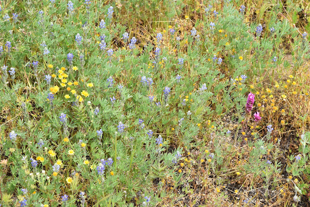 |
| A nice variety of wildflowers. |
 |
| More wildflowers. |
 |
| The nice oak forested area where I stopped for lunch. |
 |
| Tire swing time! |
Soon I reached the foothills of the mountains. Here the trail followed the Agua Caliente Creek for a while, crossing it several times. Luckily the water was more frio than caliente, so I was able to refill on water quite a bit. This section was again different than the other sections. There were wildflowers here, but different ones than the ones I had seen before. I was also seeing cool looking black lizards that had bright blue bellies. The creek was shallow and sandy and filled with tiny waterfalls. Even the trail itself was different. It consisted of beach sand that had silver sparkles in the sun.
 |
| Agua Caliente Creek. |
 |
| Blue-bellied lizards. |
 |
| A more in focus picture of Mr. Blue Belly. |
 |
| Beautiful wildflowers that look like shooting stars. |
 |
| Small waterfall in Agua Caliente Creek. |
 |
| Tiny, yellow wildflowers. |
 |
| A large succulent near Agua Caliente Creek. |
For the last 4-5 miles today, the trail started up the mountain again. The uphill was unrelenting and brutal. Everyone I past complained about it during our hiker small talk. Most of us were headed for Lost Valley Spring, a water source that also had a tent spaces. Several people gave up, having had enough of all that uphill, and grabbed the tent sites before the spring. I honestly might have done the same thing had they not been already occupied.
 |
| View of the meadow I walked through just this morning. |
 |
| I saw this little horned lizard while climbing up the mountain. |
Eventually I dragged myself to the tentsites by the turnoff for the spring. There were two Australian(?) ladies already set up. One of the guys who had passed me in the past couple miles back was there as well, but there was plenty of room for me to camp.
I left my bag at the tentsite (I can learn) and grabbed my filter and a smartwater bottle to go down the steep dirt road to the spring. The spring ended up being a concrete trough with water. The water itself looked clean, but it was standing water and there was quite a bit of debris in it. Good thing I have a water filter, right? At least there wasn't algae in it.
 |
| Lost Valley Spring |
I walked back up the road, set up camp, and made dinner while watching the sunset. The tentsite also overlooked the meadows I had walked through in the morning and it was nice to see how far had come today. Eventually 12 Pack and Sarah arrived to grab the last tentsite by the spring. It was a full house.
 |
| This evening's sunset from the tentsites by Lost Valley Spring. |


Comments
Post a Comment