Trail Day 68: Dorothy Lake (mile 996.7) to tentsite near Sonora Pass (mile 1010.8)
14.1 PCT miles
We got up about an hour later than usual, because we were planning on a shorter day of hiking. Dorothy Lake was still beautiful in the morning light. However, when I went to grab water from the lake, it had frozen completely over. I had to break through the thin layer of ice to fill up my water. Luckily, it didn't take much force to break through.
 |
| Dorothy Lake in the morning. |
 |
| Thin layer of ice covering the lake. |
I checked my camera and whatever had been ailing it yesterday, had magically fixed itself overnight. I tested the auto setting and it seemed to be estimating accurate exposure again. It was weird, but it was working again and I wasn't going to question it.
We headed over Dorothy Lake Pass, which was an easy, flat, gradual pass. It was covered in snow, which made things interesting, but it was easy to handle. This was the northern border to Yosemite and the description of the pass warned (for both northbound and southbound hikers) that the scenery would change dramatically.
 |
| Good morning. |
 |
| Julia and Phoenix clearing the pass. |
 |
| Leaving Yosemite. |
Just after the pass, Songbeard thought he had cell reception so he left the group to see if he could find signal. After a while he whistled and waved to us so we started down the trail, following footsteps in the snow.
Soon we came to a creek crossing. We didn't see Songbeard, which we thought was a little weird, but the creek was only calf deep so we thought maybe he had kept going because it was so easy.
We came to another crossing of the creek and still didn't see him. We found another crossing that was only calf deep as well, so we figured he might be waiting for us at the 1,000 mile marker.
By the time I got to the 1,000 mile marker, Phoenix and Julia were there taking pictures. They had not seen Songbeard and Sage had continued walking. I couldn't blame him. The place was heavy with mosquitos. We took our pictures with the stones as quickly as possible and got out of there ourselves.
 |
| 1,000 miles. |
Over the next couple of miles, the group spread out on the trail. The scenery had certainly changed since leaving Yosemite, but it was still pretty. There were small, reflective ponds, pine trees, and boulders.
 |
| Reflective ponds. |
 |
| Pine trees. |
I walked until I crossed the bridge over Walker River and saw both Julia and Phoenix taking a break. They had not seen Songbeard and Sage had decided not to stop. I took a break with them and then we walked separately to Kennedy Canyon Creek.
 |
| Walker River. |
This creek was the last listed (big) creek crossing on the water report. I thought for sure if Songbeard was ahead of us, he would have stopped and waited at the ford. It was lunchtime as well. I only saw Phoenix and Julia. Sage had chosen not to stop.
I forded the creek, and sat down with the other two women for lunch. We were all starting to worry about Songbeard. It was uncharacteristic of him not to wait at a ford. The other two also said that they had seen Sage’s footprints while they were walking, but not Songbeard’s footsteps. We decided to take an extended lunch break, like we had been doing the past couple days, and see if he showed up.
 |
| Kennedy Canyon Creek. |
I ate my lunch by the creek, then laid down for a few minutes. When I sat up, Songbeard had magically appeared on our side of the creek. I didn't hear him coming or see him cross. He definitely had a story for us.
Apparently he was on the real trail, and the trail we had followed to the first creek crossing (footprints through the snow) was an alternate route. He had been waiting for us in a place we never crossed for 2 hours. Then he retraced his step and found our footprints leading to the crossing. When he realized what had happened, he practically ran down the trail to catch up. After he arrived, Sage came down the path from the other side. He had the good sense to backtrack when he had been waiting down trail and no one had shown up.
After lunch we all headed towards Sonora Pass. We only had about 5 miles until the campsite we had chosen for the night. Easy, right? Wrong. It was not easy.
It wasn't long after the creek we hit large patches of snow, which made route finding difficult. The trail would be exposed for a while, then disappear under a large stretch of snow. We had to jump from exposed patch to exposed patch, mostly while walking around the snow patches.
 |
| Heading up. |
 |
| Hitting the snowline. |
Eventually it got really steep. We were also walking on some sort of loose rock, maybe shale. Every time you took a step you slid back down a little. Combine that with the steepness and an elevation above 10,000 ft and it was exhausting. I had to stop every few steps to catch my breath.
Eventually we got high enough on the loose rock to be able to do the snow traverse to the pass. From down below it looked like it was a nice ledge chopped into the snow. That wouldn't be so hard, but I got my ice axe out anyway.
When I hit the traverse, I found out it was not a ledge. They were single footprints kicked into the snow, which was slushy from being in the sun all day. And, it was really steep.
 |
| The traverse. It wasn’t so bad at the beginning, but got steeper as it wrapped around. |
After all the gradual passes we had crossed, I did not expect this pass to be difficult, so I was caught a little off guard. I went really slow and made sure every step was secure before moving forward. Even though I had done plenty of traverses by now, it was still a scary experience. This was an exceptionally long traverse and I was white-knuckling my ice axe and trekking pole.
After a very long time on the traverse, I made it to a section of exposed trail and got to rest for a bit. I needed a moment to calm my nerves. I then alternated from exposed trail to snow traverses all the way to the pass itself. Thankfully, none of the remaining traverses were as long or as steep as that first section.
 |
| Looking back at the long traverse. |
 |
| Thankfully, it got easier. |
After we reached the pass we were treated to awesome views of the other side. There was an amazing, dramatic ridgeline that the trail followed. I walked it, feeling pretty badass, for a couple miles until I bumped into the group setting up tents at the prearranged mile.
 |
| Looking back at the ascent. |
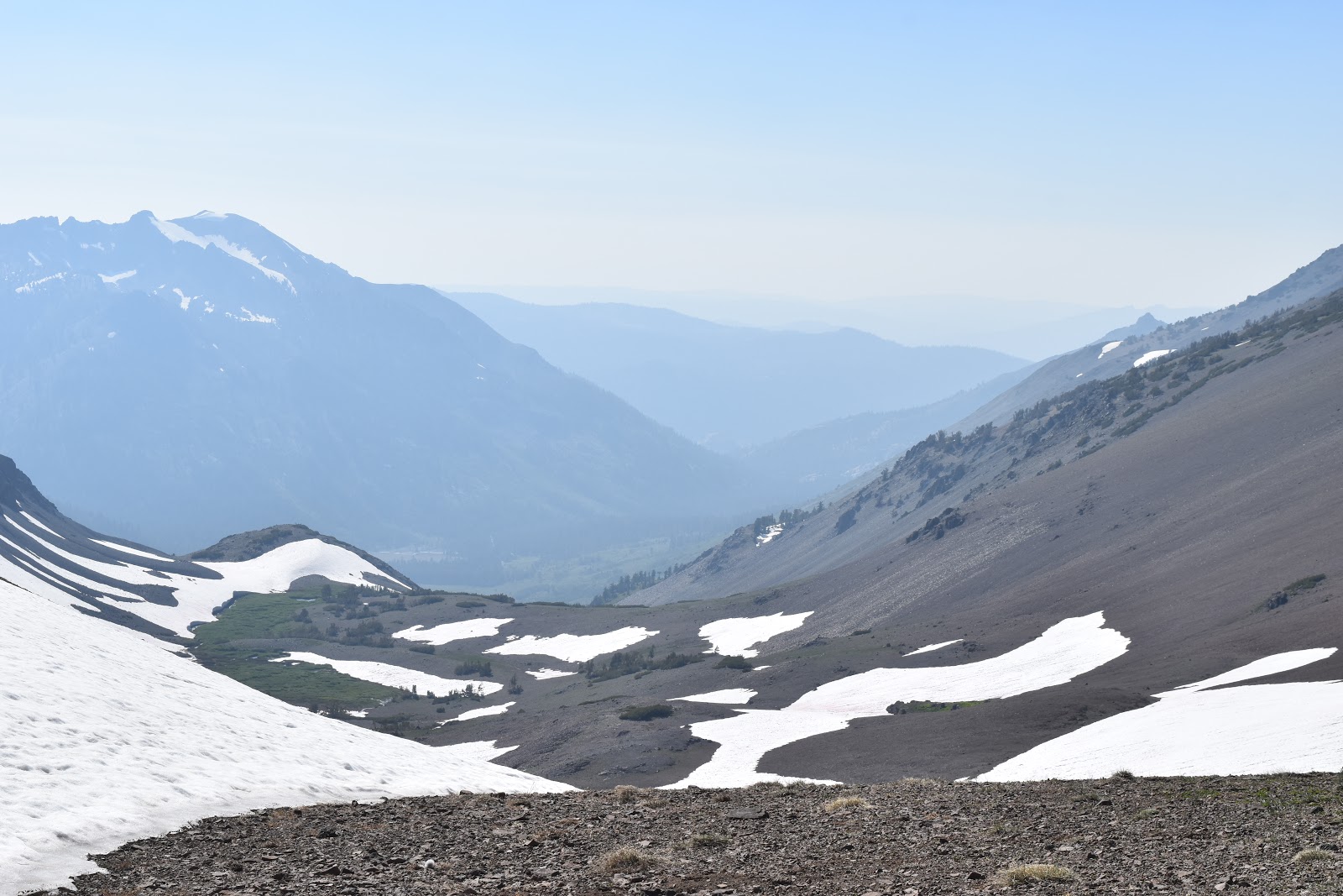 |
| View on the other side. |
 |
| The PCT heading towards the ridge. |
 |
| Phoenix walking the ridgeline like a boss. |
The ridge we were walking was mostly exposed, but there was a line of shrubby pines with big spaces between them for tents. It may be one of my favorite tenting sites so far. I set my tent up, nested in a sheltered cove. I was blocked from the wind and all I needed to do was step through the trees and I got an amazing, unobstructed view of the surrounding mountains.
 |
| My tent, nestled into the shrubs. |
 |
| Peeking out from the shrubs towards the mountain side. |
 |
| The view from the other side of the shrubs. |
 |
| Ridgeline sunset. |


Wow! What a view!
ReplyDelete