19.6 PCT miles, plus one mile backtracking
Still worried about not getting in the miles I need to do, I got up and started hiking before the sun came up. I carefully made my way down the switchbacks and across a couple streams before the red sun rose.
I stopped to check my position on my GPS and noticed there were no water sources for almost 7 miles. There has been so much snowmelt everywhere that I was not expecting that. The nearest water source was .5 miles behind me. Begrudgingly, I made the extra mile round trip to fill up on water.
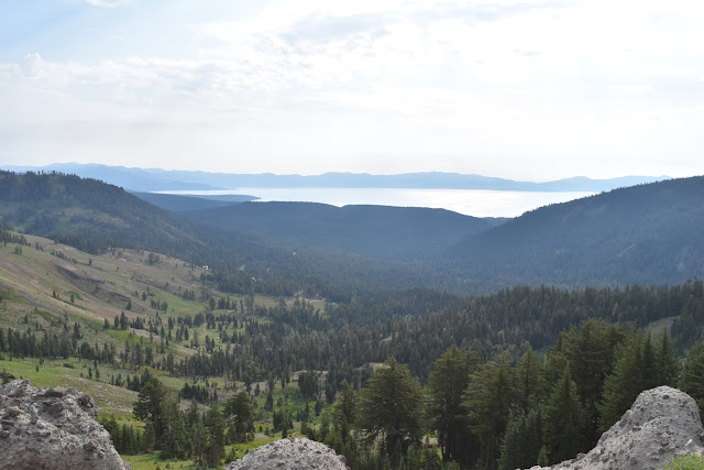
I climbed a hill and entered the Granite Chief Wilderness. For the next couple miles I walked a cool looking ridge. I got some great views of the surrounding area even though it was quite overcast. There was even a section of the ridge that was on the edge of a ski resort so I was able to check messages/internet.
 |
| Enteeing Granite Chief Wilderness |
 |
| Walking the ridge. |
 |
| View to the west of the ridge. |
 |
| View to the east of the ridge. |
 |
| Passing the first ski resort of the day. |
I started down the switchbacks that led down from the ridge and was passed by Sage. We both stopped at the creek at the bottom to have a snack, refill water, and chat like old times.
After the creek, I started heading uphill again. This is when the rain started. It lasted for hours. At the top of this climb was the ski lifts for Squaw Valley. This section seemed to be popular with day hikers. I was surprised to see so many of them out in the rain.
 |
| The PCT on a soggy day. |
 |
| View from the trail near Squaw Valley. |
 |
| Squaw Valley ski lifts. |
I headed down to another creek and then had another climb, which brought me up to a rock formation called Tinker Knob. I was dismayed at how late in the day it was by the time I reached it. Not only was I hiking slowly because of my knee, but I was having bad heel pain that was slowing me down as well.
 |
| The view going uphill. |
 |
| Approaching Tinker Knob |
 |
| Male grouse with his feathers fluffed out in a mating display. He was chasing a female grouse who seemed more annoyed than interested. |
Past Tinker Knob I looked out over a long ridgeline. It looked like the PCT would follow this windy ridge for a long time, like the one I walked in the morning. Not only would that be difficult to walk in the dark, but it also looked like there were no campsites for miles.
There was a very nice site for tents just after Tinker Knob, in a strand of trees sheltered from the wind. I figured that would be the best place for the night, although it puts me way behind schedule. I am already pretty much out of wiggle room as far as timing to complete the trail this year. I'm supposed to be averaging 25 miles days in order to finish “on time.” That is not even counting zero or nero resupply days. I may have to give serious thought to flipping up to Oregon or Washington and coming back to the Northern California section if I want to do the whole trail this year.
 |
| Cozy campsite on a windy ridge. |


Comments
Post a Comment