Formerly Susanne's PCT Journal. This is a simple trail journal of my long distance thru-hiking adventures/misadventures. Family, friends, and total strangers are welcome to come along for the journey!
-Susanne aka "Snapper"
Get link
Facebook
X
Pinterest
Email
Other Apps
Trail Day 64: Marie Lakes Junction (mile 926.9) to Glen Aulin High Sierra Camp (mile 948.3)
21.4 PCT miles
We thought we would have to start the day with a cold wade through the raging creek we camped next to last night. Thankfully, the water level had decreased enough during the night that there was a large log above the surface that we were able to cross without getting our feet wet.
Dry feet was short lived though as we started the climb to Donohue Pass, the last high elevation pass we would be crossing on the PCT. There was much less snow a couple miles out than the other passes, but the ground was soggy and sometimes flooded from snowmelt.
We eventually hit a snowfield right before the pass and put on our crampons/microspikes, but didn't even get out our ice axes.
Approaching Donohue Pass.
Taking a break on the approach.
The pass itself was another gradual, wide pass. You could look back at the approach, but then you had to walk across a wide saddle to get a view of the descent.
The Donohue Pass approach (looking back).
The descent looked beautiful. We were officially entering Yosemite National Park’s southern boundary and we could see lots of green trees and a lush meadow below. The snowline was pretty high so there would only be a little bit of snow travel on the descent.
The descent into the southern portion of Yosemite National Park.
We went down some traverses, hit a small body of water right at the edge of the snowline, then took a lot of switchbacks down into Lyell Canyon and Lyell Meadow.
A frozen lake early in the descent.
Headed down the switchbacks. You can see the eadge of the snowline to the right.
Approaching the meadow.
This meadow may be the most beautiful meadow I have seen. It was surrounded by snowy mountains; had a creek with clear, turquoise blue water running through it; had a waterfall running down into one section, and had a smattering of yellow wildflowers.
Lyell Meadow.
Wildflowers in the meadow.
Whitewater waterfall flowing down into the meadow.
Clear stream flowing through the meadow
This meadow extended for about nine miles, but it was flat, so we took it at a good pace to try and get some decent miles in today.
Part way across the meadow.
The PCT.
The forest next to the meadow.
After the meadow, the trail ran next to Tioga Road. After being in the wilderness for so long, it was jarring to see cars drive by next to you. The trail crossed Tioga Road at the parking lot I had used to climb Lembert Dome last year.
We followed a gravel road and it took us to the trail around Tuolumne Meadow (the actual meadow and not the campsite), where we came across Soda Springs, an area where the water bubbles out of the ground carbonated. Songbeard filtered some of the water to try, and we all got a taste. The water retained its carbonation after it was filtered, so it was kind if like sparkling water. However, it kept an iron taste after being filtered so it tasted like iron sparkling water.
Tuolumne Meadow.
Wood structure surrounding the main spring at Soda Springs.
Carbonated water springing up from the ground.
By this time it was late in the day, and I was really being bothered by foot pains, so I was going much slower than everyone else. I limped the two more miles to Delaney Creek, which was supposed to be a difficult crossing, with water potentially waist high. When we got there, I doubt it would have been much higher than our knees. There was a large log just upstream that was easy to cross, so we didn't have to wade through it anyway.
Next, I limped towards the junction for Glen Aulin, where we were going to meet and push a couple miles further to a campsite. This section changed dramatically in scenery and was very “Yosemite” to me.
We were walking next to the Tuolumne River and you could see large granite peaks and domes in the distance. We also crossed swaths of granite that were so wide that there were rock cairns placed for navigation.
Yosemite High Country.
More Yosemite High Country (mountains slightly hazed out by smoke)
Cairns marking the way (up and to the right).
Large swaths of granite.
Eventually I came to the bridge that crosses the Tuolumne River. A few weeks ago, the water level was above the bridge, making it unusable. I have no idea how the hikers that were going through navigated the trail during that time.
Bridge over the Tuolumne River.
The Tuolumne River.
After the river crossing, the trail started to lead down. The sun was low in the sky and casting everything in a golden light. It was really pretty. I had to wonder why we were racing through all this to try to get “big miles” in.
Boulders marking the PCT route.
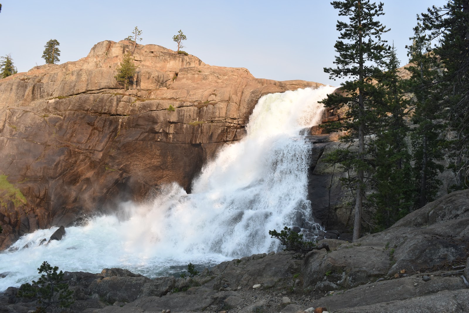
The trail lead next to Tuolumne Falls, which was spectacular. There was such a high volume of water flowing through it. I stopped to take a picture, then went down the trail and found the rest of the group admiring the falls from a lower vantage point.
The upper part of Tuolumne Falls.
Tuolumne Falls.
Tuolumne Falls in action:
Looking downstream from the falls.
As we rested, Songbeard quizzed the group about how they were feeling about campsites for the night. With my foot issues, my vote was for the next available site. It seemed like most of the rest of the group was also leaning towards being done for the day as well.
The sun setting a little further downstream from tge falls.
We continued down to the bottom of the falls and the junction for the Glen Aulin High Sierra Camp. Usually this is a reservation only campground, but it was not officially open, since the bridge had washed away from its foundation. There were log crossings to get over the stream, so we were still able to access it to set up our tents on the sand next to Tuolumne Falls.
The bridge to Glen Aulin.
Where the bridge to Glen Aulin used to be.
It was a beautiful spot, but the mosquitos were intense. I put on bug spray, my rain jacket, my rain skirt, and my head net to keep the cloud of mosquitos away while I set up my tent.
One last sunset photo, looking downstream from the Glen Aulin camp.
20.3 miles Just like the past few mornings, it was difficult to get up again. Unlike the past few mornings, I could actually see snow on top of my tent. It was supposed to rain or snow on and off the majority of the day again. That was not a motivating thought to get me out of my sleeping bag. I had also finally used the hand warmers that I had purchased back in Flagstaff, and they were still warm inside my bag. Somehow, I emerged from that bag and packed everything up one last time. I was only about 20 miles from the Utah border and on schedule to finish the trail today. Most of the items I had on me were damp or wet. It didn’t bother me packing them up as I knew I would be warm and dry tonight. What did bother me was having to put on my wet, cold, dirty shoes. After I did that, I had wet, cold, dirty socks as well. In Flagstaff I had also picked up toe warmers, so I stuck those inside my shoes and hoped that they would help. The view looking out of my tent. My camps...
26.6 FT miles I had meant to get up really early this morning. There were only two places in the St Marks National Wildlife Refuge where you could camp, and there was one that was supposedly one of the best, if not the best, campsite on the trail. However, it was over 26 miles away. Some of those miles were going to be road walks, so those parts would go quickly. On the other hand, if we encountered swampy areas, it might be a very long day. A little before dawn I yelled over at Sugar Rush to see if she was awake, which she was. We packed up in the dark and, just like last night, went crashing through the brush trying to stay on trail. There were some parts that were clear and other parts that were not so clear. When the sun came up, things didn't necessarily get better. We started to realize why we were having so much trouble last night. Even with daylight we couldn't always track the path on the ground and had to search as a team for hidden blazes. The river made...
27.1 miles I tried looking at what the day had in store for my on the Arizona Trail app. Pretty much the only things labeled were forest roads, trail junctions, and stock tanks. Nothing too exciting. The morning turned out mostly as described. I left the tank I camped at last night on a forest road, then joined another forest road, then a footpath for a short while, then another forest road. Hiking a forest road. The signs could have been a little better in this section. I had to keep looking at my app to make sure I knew where to turn. After a while the signage got better and I turned onto another footpath. A footpath section of trail. I was heading to a spring I wanted to use as a water source. When I checked the app, it showed me off trail. I knew I couldn't have been off trail because I turned at a very clear “Arizona Trail” sign. On the app, the trail followed forest roads. I figured the footpath must be new and the app hadn't been updated...


Wow! Absolutely stunning!
ReplyDeleteYosemite. ;)
Delete