Trail Day 48: Tentsite (mile 1.9 of John Mui r Trail Detour to Mt Whitney) to tentsite (mile 767.2)
0.3 PCT miles, plus 14.1 miles to Mt Whitney and back
I managed to successfully set my alarm and get up early today. Today was going to be a big day. I was going to complete everybody’s favorite side trip of the PCT, summiting Mt. Whitney, the highest peak in the contiguous United States.
I got going around 4:45 am. There was a large snowfield early on in the hike at Guitar Lake. I wanted to hit it while it was still firm. Getting up early also gave me a lot more time to work with to complete the hike.
I only walked in the dark with my headlamp for a little bit. By the time I finished filtering water from Timberline Lake there was enough visible light to turn the headlamp off. Soon after Timberline Lake I hit the snow.
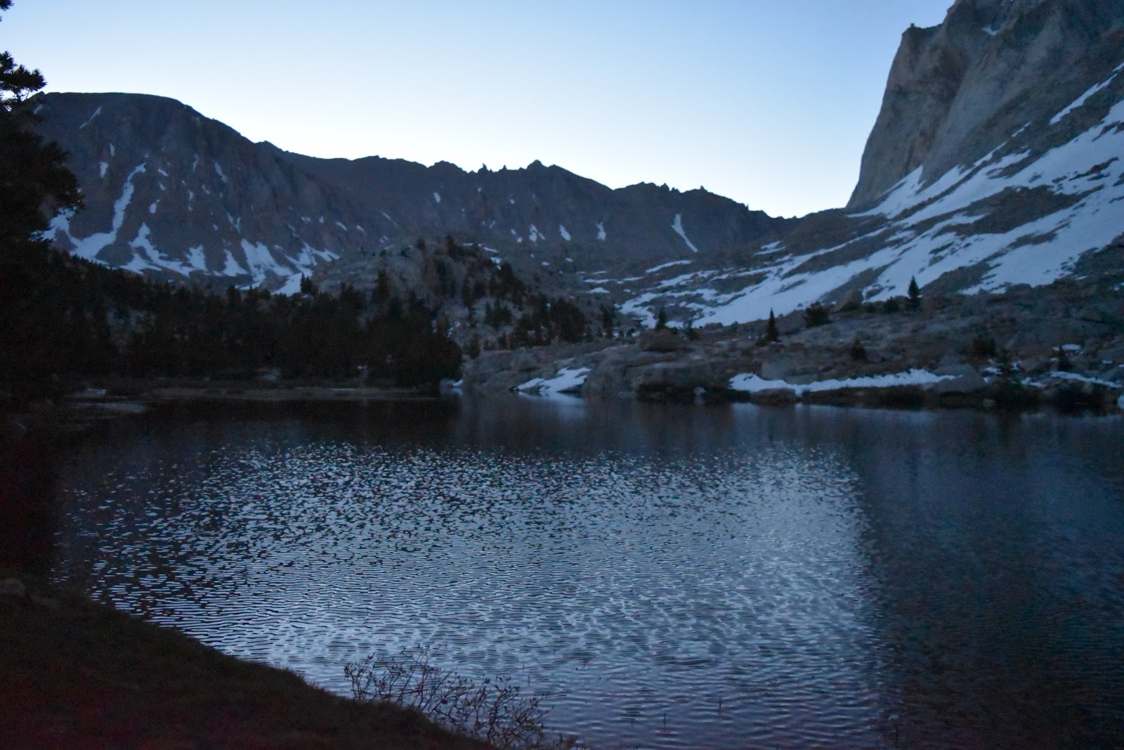 |
| Timberline Lake in the early morning. |
I put on my crampons and started across the snow. The snow was sun cupped, which is a phenomenon that happens during the freeze/thaw cycle. The snow doesn't melt evenly, so it creates footprint like depressions that then freeze in the night.
 |
| Looking back at the sunrise from the edge of the snowfield. |
I have never walked on sun cups before and I do not like them. The depression is too deep and too uneven to step into. The parts surrounding the depression are generally too narrow to put your entire foot on. With a normal shoe I would put my arch on it to walk, but the crampons do not have spikes in the arch. Instead I had to hit those parts with the front of the crampon in almost a tippy toe motion. It made walking across the snowfield very time consuming.
 |
| Sun cups (in the afternoon ). |
Navigation across the snow was also a challenge. I knew roughly where the trail would go but picking the correct route was tricky. It is the beginning of the melt and I could sometimes hear water rushing underneath the snow, which meant to snow was hollow. I also had to steer clear of boulders as they were also melting the snow around them creating voids.
I had to cross a stream that flowed into the lake. After assessing the crossings near the trail, I decided to hike upstream (and uphill) to where either the flow lessened or it got narrow enough to jump across. Not finding either of those solutuons, I found a solid snow bridge to carefully walk across.
Crossing the stream the way I did took me way out of the way. I wasted a lot of time. I hiked back down to the lake itself, then followed the shore, and then started heading uphill again away from the lake, and towards the Mt. Whitney switchbacks. As I looked down from a higher elevation I could see a group of people having a discussion about how to cross the stream. I'm glad I wasn't the only one who had trouble.
While I was doing this morning hike, the sun started to illuminate everything around me which consisted of jagged rocks and frozen lakes. Pictures would not do this justice. It was an incredible and overwhelming experience. The kind that is so beautiful that it makes you want to cry.
 |
| Granite peaks slowly lighting up. |
 |
| Ditto. |
I stopped at the last guaranteed water source to grab another liter of water. Most of the water I have been getting in the Sierra is snow melt, but this water was literally melting snow. I got it from the edge of a snowfield.
While I was filling up with water, the group of people I had seen earlier arrived to also fill up with water. They were another group of PCT hikers named Muffin, Purple Rampage, Dodger, Dom, and Flame. I told them my story of coming off trail, then not knowing anyone to hike with when I got back on. They agreed to help me up the trail to Mt. Whitney.
The higher up in elevation we got, the more the snow disappeared, so we were alternating between dry trail and snowfield for a while. I was happy to see that some of the members of the group were also slow hikers, although they were still faster than me. The group would take breaks and wait for everyone to catch up.
Eventually we got to the infamous switchbacks, which were long, extensive, and would cover most of the elevation gain. We were getting great views, but they took forever. The only redeeming thing about the switchbacks was that a pika (an adorable mammal that only lives at very high elevations) took a break with me on the rocks at one point.
 |
| My pika friend. |
 |
| View back down to the valley. |
 |
| Great view of Guitar Lake |
By the time we hit the junction with the trail that leads to the peak (about 2 miles to go) the elevation and exertion was really getting to me. It was hard to put one foot in front of the other, I was breathing heavily, and I had a headache. I really wanted to turn around and head back.
The next two miles to the summit just reinforced to me that I wanted to turn back around. I almost did just that in this section. For the most part it wasn't a flat trail. It was full of jagged rocks which required stepping up, stepping down, and a bit of scrambling. That last part to the peak was a legitimate scramble, with cairns to show you the path you should be scrambling. I could only do a couple feet at a time before stopping to catch my breath.
 |
| The trail to the summit. |
 |
| View to the east through a gap in the rocks. |
Finally, I got a glimpse of the stone shelter built at the top as well as other hikers milling about. I made my way to the shelter and signed the register. I took a peek inside the shelter, but the door must have been left open this winter because it was filled with snow.
 |
| The shelter on top if Mt. Whitney. |
 |
| Oops. Someone left the door open. |
I set my bag down by the group I had been hiking with and took in the views. To the east was a clear view of Owens Valley, Highway 395, and the town of Lone Pine. Every other direction was snow. There is so much snow in the Sierra, and it is right in the area I am headed.
 |
| Summit plaque. |
 |
| Owens Valley and Lone Pine to the east. |
 |
| Snow. |
 |
| More snow. |
 |
| Me in front of the snow. |
The group of PCT hikers I met yesterday arrived at the peak about a half hour after us and we all sat on the peak eating,and chatting. Then my group started back down again.
The switchbacks were less cardio heading down but still long and difficult. I was also getting a headache again. Despite this I still got to appreciate that there were only two plants that grew at this elevation, and both were wildflowers. There was a purple variety and a yellow variety. They were the only things growing out of the barren rock.
 |
| Yellow wildflowers. |
 |
| Purple wildflowers. |
By the time we got back to the snow section, the snow was now slushy. It made walking and navigation difficult again. And, my feet were getting wet. The melt was changing the landscape quickly. The area around Guitar Lake already looked different than this morning as there was more water and more of the actual trail underneath the snow was exposed.
 |
| Guitar Lake in the afternoon. |
By the time I made it out of the snow I was exhausted. It was also late in the afternoon. The area I was walking through was gorgeous with gushing water, lakes, jagged mountains, green vegetation, and marmots (everywhere). However, I was worried about getting back on the PCT itself and I still had a headache, so the scenery was difficult to enjoy.
 |
| Finally coming out of the snow. |
 |
| Marmot hiding in the rocks. |
 |
| Marmot out in the open. |
I had stashed half my gear back at my campsite so that I wouldn't have to carry as much weight up the mountain today, so I ran back to go grab that. On my way I bumped into a ranger who was inquiring if I had seen a missing hiker. There had been helicopters circling in the afternoon, so I wondered if that could be why. He asked what the last name was on my permit, which I took as another, “In case I need to say that I've seen you.”
After grabbing the rest of my gear and getting some food, I put on my heavy pack and started back towards the PCT. The general plan among the two PCT hiker groups was to hike a couple miles to before where the next set of creek crossings were and camp there, hitting the creek crossings early in the morning when the flow wasn't so bad.
However, when I bumped into the group I had been hiking with today, they were going to camp in the same spot as last night so they wouldn't have to do anymore hiking today. I noticed several members of the other group also in their tents set up from the night before.
I decided to try and get those couple extra miles in, but the last stretch of the John Muir Trail to the PCT intersection was all steeply uphill. It was then that I realized how exhausted I was from the day, so I grabbed the first campsite that came along after I rejoined the PCT.


Comments
Post a Comment