Trail Day 49: Tentsite (mile 767.2) to Base of Forester Pass (mile 778.5)
11.3 PCT miles
Since I was camping alone, my plan for the day was to get up really early, go to the next water source by daybreak, and then hopefully get to the first challenging creek crossing before or by the time one of the other groups got there.
However, when my alarm went off I reasoned to myself that I could sleep in an extra half hour, especially since I wouldn't be doing that many miles today. Unfortunately, I saw the group I had been hiking with yesterday pass by as I was packing up.
I rushed to get my bag packed and headed out, wondering if I could catch them. I had to stop to filter water, since I had used up all my water from last night. I probably wouldn't catch them.
 |
| Morning view from the trail. |
After I got the water, I started heading towards the first crossing, Wallace Creek. Luckily, the group I had met two days ago (the one that travels in a train formation) passed me. It looked like I would have people to cross the creeks with me after all.
They passed me by, but we all met again at a seasonal stream that was a calf deep ford. After we crossed, they chugged on ahead, but then I met them again at Wallace Creek. They scouted out the various places to ford and we decided the trail crossing itself was the best spot to ford. We spaced out and all forded together. After that everyone dried out in the sun.
 |
| Wallace Creek at the trail crossing. |
As I know I am a much slower hiker than the rest of the group, I started out before them and reached the next crossing, Wright Creek. I saw a note under a rock that stated a group who had been there before us could not find a crossing .5 miles upstream as had been reported by previous hikers. There was, however, an area downstream where an island split up the flow. There were two short, shallow crossings to get to the island and a large log to cross the big stream.
 |
| Log crossing at Wright Creek. |
 |
| Water raging upstream at Wright Creek. |
Just as I was scouting this out, the group showed up. They also scouted and eventually we found the area to cross. The two streams were strong, but only ankle deep. The log looked scary at first, but ended up being an easy cross. We dried out again afterwards.
This time the group had packed up and left before I was ready. This was a problem since they walked much faster than me and the next crossing was over 3 miles away. It was also the trickiest crossing of the day.
I started walking uphill, which is something I do very slowly. I walked up getting great views of the meadow and the surrounding mountains, eventually reaching a saddle.
 |
| Trail views. |
 |
| The PCT. |
 |
| More trail views. |
 |
| Even more trail views. |
The saddle was right at the snowline. Sometimes the trail was buried, and sometimes it was visible. There were also marmots everywhere. I followed the trail as best I could, sometimes walking on the snow, sometimes walking on the trail.
 |
| Patchy snow on the saddle. |
 |
| Marmot |
 |
| The snowline. |
Finally, I hit the other side of the saddle and started heading down to Tindall Creek. There were annoying, lingering snow banks that I had to constantly make my way over or around on the way down. It made everything more exhausting.
Eventually I hit the bottom where the Ranger Station was and was surprised to see the group hanging out. I thought they would be much further ahead. Apparently they had made a stop to the Ranger Station which was lucky for me. It meant I could scout out the last crossing of the day with a group.
We first went to the official crossing to take a look. It was a raging whitewater torrent. There was no way we would consider crossing there, but we wanted to see it anyway. There was a note at the PCT crossing saying to cross in the meadow upstream.
Tindall creek near the PCT crossing:
We kept walking until we saw other people who had just crossed. There was a spot that was about knee deep where we decided to cross. The flow was still very strong so two of the guys positioned themselves in the middle to catch anyone if they fell.
 |
| Crossing Tindall Creek at the upstream meadow. |
Everyone crossed without incident and we headed up to where the PCT was to dry out. The ranger came by at that point to check permits and answer questions. She said that the snowfields were 2 miles on the approach and 3 miles on the descent.
The group wanted to camp as close to the pass as possible tonight, something I was totally OK with. There was a campsite a little over 3 miles away that was about a mile away from the pass itself. Since we would be camping on snow (which wouldn't be very easy to hang out on), the group decided to wait until the late afternoon/evening to hike up through the snow and set up camp. Therefore, we spent several hours hanging out in the valley near Tindall Creek watching marmots scamper about.
 |
| Hanging out on the PCT above Tindall Creek. |
After drying off and napping, some of us used a nearby snowy slope to practice glissading (sliding down the snow on your butt) and self -arresting ( using the ice axe to stop you from sliding down the ice). It turned out to be horrible snow for that. It was soft and sun cupped. I couldn't slide very far on either my glissade or my self arrest practice. It was still good to go through the motions though.
My practice ended up being snow play. I was kind of rolling around in it and got soaked. As I went to dry off in the sun, others engaged in snow play as well. Lucky built a snowman and some of the guys started a snowball fight.
 |
| Wanna build a snowman? Lucky did. |
As the afternoon hit, it was time to leave. I headed off first by myself because I am a much slower hiker. The trail alternated between exposed and covered in snow. Eventually it became a snow field. I had to keep checking my navigation to make sure I was headed in the right direction.
I started moving between dirt islands in the middle of the snow field, going in the same general direction as the trail. Eventually, I saw a nice traverse kicked in on the slope above me and went uphill to join it.
 |
| The traverse already kicked into the snow. |
I also found a nice water source among the boulders and started filtering water. While I was doing this, I saw the rest of the group way down in the basin below. They decided to ignore the traverse, cross the muddy basin, and go straight up the slope on the other side. I took the traverse to meet them as they rested on some dry rocks.
 |
| Looking back at the basin. |
 |
| The group choosing the basin route. |
Eventually we continued on, following the footsteps on the snow. Those footsteps stopped at a wide stream that we unexpectedly had to ford. Then we had to create our own steps in the sun cups from there on out. I hate sun cups.
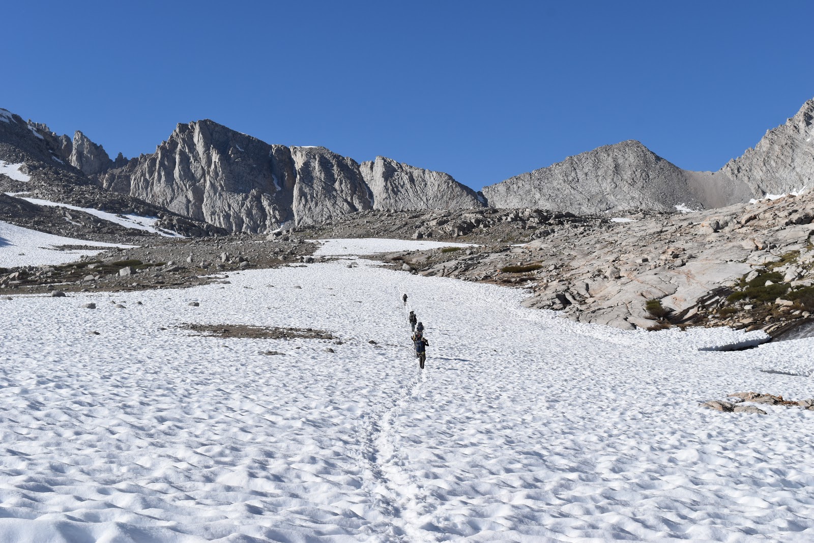 |
| Cut trail leading to Forester Pass. |
It was slow moving the rest of the way. My shoes and socks were absolutely soaked from slipping and sliding on the sun cups. The elevation wasn't helping things at all and it became very difficult to take steps.
 |
| Beautiful and random cascade near Forester Pass. |
The group found an area fairly close to the switchbacks to the pass that had dry boulders and sand to camp. We set up our tents and ate dinner, but it got cold very quickly so everyone rushed into their tents. From the switchbacks it will only be a mile to the highest pass on the PCT.
 |
| Near the base of Forester Pass. |


Comments
Post a Comment