Trail Day 53: Tentsite (mile 788.8) to tentsite near Woods Creek (mile 799.7)
10.9 PCT miles, plus a lot of unessesary extra walking
Well, today was a hot mess. I started off the day by heading down the trail withthe guys I camped with last night, including Stranger Danger, Spice Merchant, Dragonfly, and Boulder.
After a while we realized that we were headed to a pass, but, for some reason, we kept heading downhill. By the time we checked GPS, we were 0.8 miles off trail. We backpacked and discovered that the trail junction sign was partially submerged in the middle of a pond. No wonder we missed it.
 |
| Can you spot the trail sign? |
When we got to the PCT, the boys took off ahead as they are much faster walkers. I had some dry trail for a while, but eventually I put my crampons on and carefully made my way across and towards Glen Pass.
 |
| View on my way to Glen Pass. |
I had been walking by myself for a while when I heard a voice above me. It was the boys sitting way up a snowbank on the edge of a rock field. They told me they were going to take a route across the rock field, but if I didn't want to do any scrambling, that I could stick to the trail.
I attempted to stick to the trail, but it wasn't fully exposed and I was doing some scrambling anyway. Figuring that the boys had seen a way to cut the trail, I climbed the snowbank and tried their route.
I cut across the rocks, but only found a ledge and no trail. I went a little higher and tried it again. I must have done it at least 5 times and was nearing the top of the rock field. Each time I would reach a ledge. Meanwhile, I saw southbounders on the trail itself, seemingly having an easy time with it.
I realized I would have to backtrack which almost made me break down. I had wasted so much time and I had exhausted myself. I would have to scramble all the way back down the rock field, then carefully pick my way back down the snowbank, just to start the climb again from the trail. I wanted to cry, but the rational part of my brain realized that wouldn't help anything.
I made my way back to the real trail. It was slightly downhill from where the snow trail lead, which is how I missed it the first time. I was really tired as I tried to make it uphill. I had to stop quite often and I knew the boys must be angry wherever they were waiting for me.
I saw them hanging out on some bare rock closer to the pass, and, when they saw me, they started up again. I very slowly made it to the rocks and had to take a quick breather, before starting up the last, and steepest part of the pass.
Thankfully there were good steps already kicked in on the steep part. However, I was so exhausted. I had to literally say out loud, “Foot. Foot. Foot,” in order the get my body to step in each footprint. When I got close to the top I heard a voice say, “You are almost there.” It was Stranger Danger who was keeping an eye on me from the last couple switchbacks that were exposed near the pass.
 |
| Glen Pass. |
 |
| Exposed switchbacks near the pass. |
 |
| View from Glen Pass looking back at the approach. |
 |
| View from Glen Pass looking towards the descent. |
I made it to the switchbacks and reached the pass where everyone else was waiting. I tried to explain my misadventures with the shortcut and how it made me so tired, but apparently they had done the same thing and had to backtrack to the real trail as well. I wonder how I missed them.
Now we just had to get down the other side. It was incredibly steep and we had to get down to a series of lakes below. We saw two traverses already stepped into the slope, one going low, one going high. Dragonfly and Boulder took the lower route while Spice Merchant and Stranger Danger took the higher route. I checked the GPS on my phone and it looked like the higher route more closely matched the trail underneath the snow.
I took the high route and it was easy for a while. Unfortunately, it turned out that the low route was the better route. They both took you to an exposed rock field where the trail switchbacks were, but the lower one took you to usable switchbacks. The upper one took you to a dangerous scramble.
 |
| Top and bottom traverses leaving Glen Pass. |
We ended up having to kick our own steps into the now slushy snow to get to a safer spot. Luckily, the two guys had gone before me, so I had something to work with, but it was still nerve wracking.
There was a small, steep part where the guys had decided to glissade to the lower path. I ended up doing it too, but it had to be very controlled in order to stop at the path but I managed to successfully do so. One of the guys had dropped a water bottle on the glissade. It was Stranger Danger's water bottle, so I walked part if the traverse and tossed it back down to him on the switchbacks.
I finished the traverse and started down the switchbacks until they dissappeared again. From there I could have scrambled down some rocks or used a very long glissade. While I was standing there looking at my options, I heard a voice ftom below say, “Use the glissade.” Ok, mysterious person. The glissade was long but ended up being one of my favorites so far. I was never out of control and it even weaved around a little like a water park slide.
 |
| Part way down the descent. |
 |
| Looking back up at the traverses and glissades coming down from Glen Pass. |
The guys were pretty anxious to get to the next two challenging water crossings of the day, so we didn't sit for very long. As we were getting up, I reached for my pocket to check the distance to the next location and my phone was gone. I had lost it somewhere on the descent.
That is when the panic set in a little. That is an expensive item to lose on a snowy slope. It is also how I communicate with the outside world, check stream crossing/ford information, navigate, write my journal entries, and set my alarm for the mornings. I could not accept that it was lost. I was also really tired from coming over the pass.
I figured it must have fallen out during one of the glissades. I usually put my phone in the zippered pocket of my pants for glissades and fords, but I had been so tired that I had forgotten to do so. The first glissade had caught me by suprise as well, since it had just been a shortcut to a better traverse. There was also a possibility that it had fallen out during one of the three times I had put on my backpack.
I started to scramble back up the rocks to where the beginning of the second glissade was. Stranger Danger had offered to help and had gotten there first. He did not see a phone on the glissade or near the rocks where I had put my pack on. As we scrambled towards the traverse and the first glissade, I realized something. I did not have paper maps for back up.
I have always carried paper maps as a back up until this stretch. I had sent myself a resupply box to Independence, thinking that I would be spending my zero in the trail town. My Trail Angel had split my resupply into three separate boxes. Somehow, the box with my maps and town information had gone to Georgia.
I needed to find the phone. I passed the lack of paper map debacle on to Stranger Danger to stress the importance of finding the phone. He had hit the traverse before me and told me to stay on the rocks because the snow had gotten really soft.
A couple seconds later he had found my phone! It was at the beginning of the first glissade. He had climbed almost all the way back up to the pass to get it. I actually cried briefly with relief (and probably exhaustion). Stranger Danger is a hero.
We made our way back down to the rest area below, which was much easier without the big, heavy backpack. Then, the group pressed on through the snow.
We thought the snow was going to be a gradual slope down to the lakes, but there ended up being some steep sections and I fell behind again. I found one of the guy’s water bottles that they had lost on another glissade and carried it down the slippery snow to where they had stopped for lunch.
 |
| Continuing with the descent. |
After lunch we walked the rest of the way down to the lakes. We got to a very scenic part of the lakes where the trail goes in between two of the Rae Lakes. However, the lakes were so swollen that one of the lakes was overflowing into the other. It ended up being a cold, crotch-deep ford.
 |
| The frozen part of Rae Lakes. |
 |
| Another view of the frozen section of Rae Lakes. |
 |
| The clear water of Rae Lakes. |
 |
| Spice Merchant and Boulder fording the overflowing section between lakes. |
 |
| Stranger Danger standing next to Rae Lakes. |
After this, the trail did a grand tour around the lakes. Much of the tour we were not able to see because it was under snow. Sometimes it made sharp turns that we couldn't see. We got off trail a lot and did a lot of backtracking. The snow was also, soft, slippery, and sun cupped, so everyone was falling a lot, and occasionally someone would posthole through the snow.
 |
| More snow around the frozen Rae Lakes. |
 |
| Buried trail sign. |
 |
| Mountain reflection in the lake. |
Eventually, the trail became mostly exposed with the exception of those annoying, lingering snowbanks. The boys then took off ahead of me, but I was glad to see they were never too far ahead, because it looked like they were tired too.
 |
| Finally, less snow. |
 |
| I see grass! |
We got to our first water crossing, where the trail crossed the Arrowhead Lake inlet. We had to go a little bit further down according to where the ranger’s note said to cross. It still looked pretty swift in this area, and it was right before a bunch of rocks. A couple of thr guys tested it out and it was a bit swift in spots, but managable.
We all crossed without issue, but it was cold, so we had to dry our feet out a little. It had become overcast in the afternoon, so I was starting to get cold. It was about a mile and a half until the next water crossing, so I started walking down the trail before the boys.
There were still patches of snow, but also some nice, dry trail. It was nice to take my time, especially with how tired I was from all the extra, unessesary exertion I had done. The guys caught up just as we were dipping down into the valley (finally!).
 |
| I see the valley. |
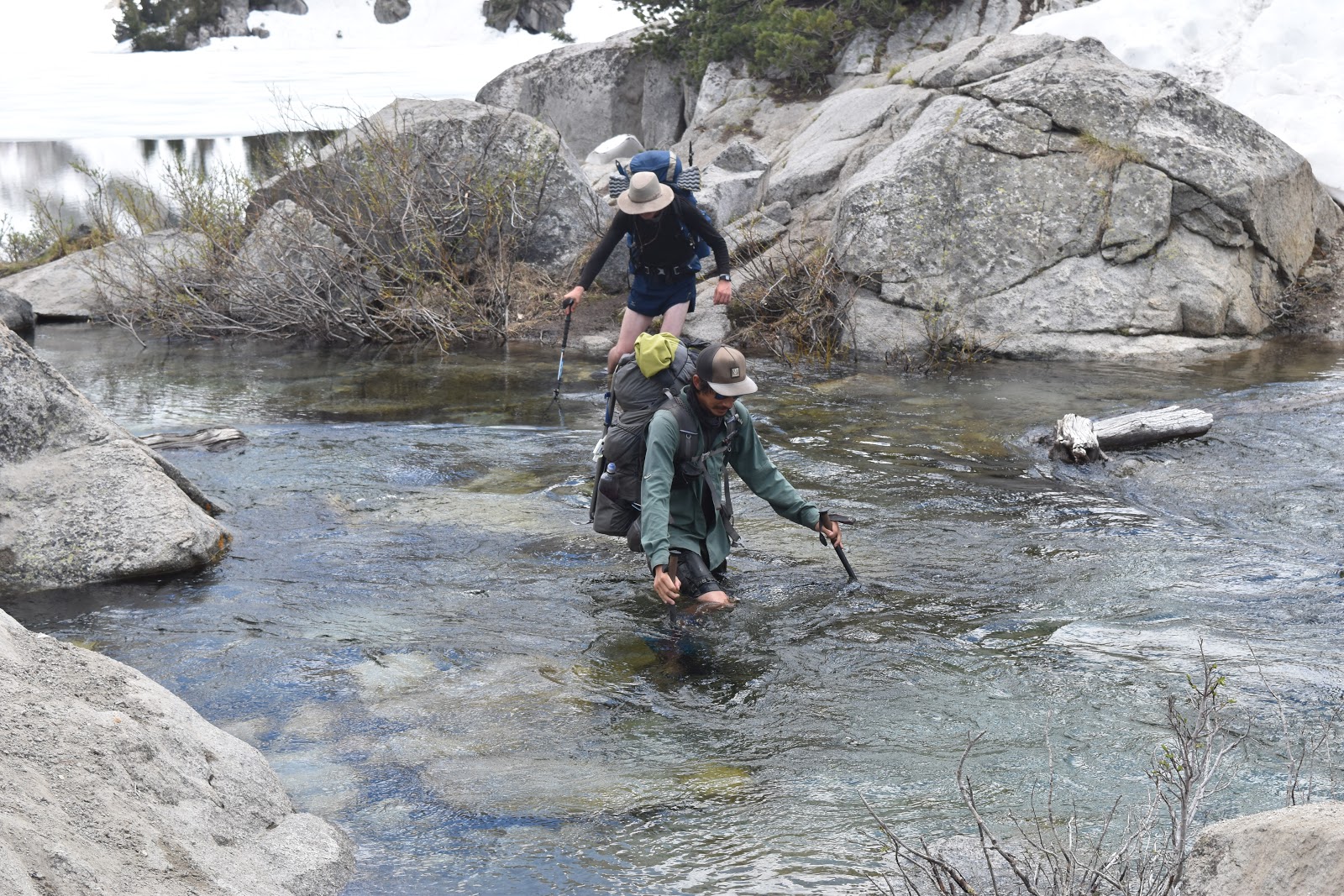
Soon we reached Baxter Creek, which we were a little worried about since someone in the water report had claimed it should probably be done as a group crossing, where people either link arms or create an “I” formation to break up the current. We were a little worried that we wouldn't be able to cross at all because it was late in the day, when the creeks are usually the swiftest because of snowmelt.
A couple of the guys tested the current and, even though it was swift, it was still managable since it wasn't so deep. We all crossed and waited dried off on the other side.
 |
| Stranger Danger Crossing Baxter Creek. |
The guys would be camping near there for the night. It was the meeting place for the rest of the “family” to catch up. The first day coming back on the trail, some of the family had a hard time getting a ride from Bishop and did not make it over Kearsarge Pass by the end of that day.
As a result, we were behind schedule (where we would try to hit one peak per day). Stranger Danger was taking about doing an 18 mile day tomorrow to put us back on schedule and at the base of Mather Pass, reported to be the scariest pass on the PCT. I thought that was pretty ambitious, considering we hadn't even gone 10 miles yet today, although we did waste some time with a lot of unessesary activity.
As unlikely as I thought 18 miles would be, in Sierra terrain, I couldn't discount them doing it either. They were a fast group and could really get going if they needed to. I also knew I couldn't keep up if they did and that I definitely needed then around for Mather Pass.
I looked at the trail coming up, and it looked like it dipped down in elevation to the bottom of the valley, then went uphill for 7 miles to Pinchot Pass. I could not keep up with the group on dry trail, and I was even slower on the uphill sections. I decided to camp about 2 miles past them at a campsite near the Woods Creek Bridge.
This site was at the bottom of the valley, so I could get a head start on the uphill climb tomorrow. If they were really going for the 18 miles tomorrow, they would catch me in no time on the climb out of the valley. It would also mean that I would be doing, at the most, 16 miles. That would still be very tough, but was a little more doable for me than 18 miles.
I slowly made my way down the valley. The further down I got, the more the soil was saturated with water, and the more bugs there were. At least it was warmer as I came down in elevation.
 |
| Making my way down the valley. |
 |
| Woods Creek Suspension Bridge, fully intact. |


Comments
Post a Comment