Formerly Susanne's PCT Journal. This is a simple trail journal of my long distance thru-hiking adventures/misadventures. Family, friends, and total strangers are welcome to come along for the journey!
-Susanne aka "Snapper"
Trail Day 27: Tentsite (mile 411.7) to Messenger Flats Campground (mile 430.4)
Get link
Facebook
X
Pinterest
Email
Other Apps
18.7 PCT miles
It was cold in my tent this morning, and my sleeping bag was warm, so I took my sweet time packing up. When I finally headed out, I could see that I was above the cloud layer again.
Good morning from mile 411.7.
The PCT followed the ridge I had camped at for a little while, going through pretty pine forest area that was dotted with orange-yellow flowers. After that it started heading down the sides of the mountain, giving really nice views along the way.
The PCT looking very pretty (and flat!).
Flowers and pine trees.
Views from the ridge.
Along with the views there was plenty of poodle dog bush. I had a moment of panic when I almost brushed up against one as I groggily started my morning. I would have to be extra vigilant today because there were plenty of reports of the plant throughout the entire section I would be walking. Sure enough, I saw plenty of reminders early on that I was in poodle dog country.
Hello, hiker. We just want to make sure you are paying attention.
#poodledogproblems
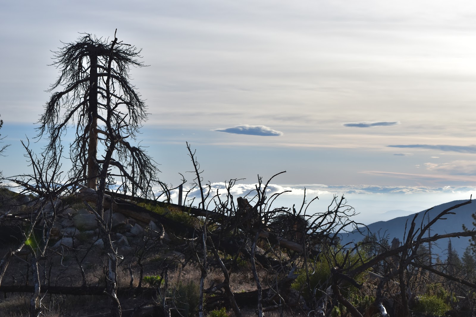
Eventually, the trail went down in elevation enough that I was at the edge of the cloud layer. As I sat on a rock I watched the tops of the cloud drift over the ridge, then completely dissipate on the other side.
Then the trail went into the cloud layer itself. The hike got pretty mysterious looking for a while. Mysterious, but cold. The clouds didn't start to part until I was almost at the Mill Creek Fire Station.
Patchy cloud layer in the mountains.
Inside the cloud layer (and a burn area).
The mysterious side of the PCT.
There is a trail here, right?
The Mill Creek Fire Station is a popular stop. There are some day use picnic tables, a pit toilet, and a spigot to refill your water. The spigot was highly pressurized and I accidentally gave myself a shower when I turned it on. It was fun to watch everyone else come in and try to get water. It was less fun, however, when I realized that I was the only idiot who stood right in front of it when I turned it on.
I got to know some of the other hikers while getting water. There were my neighbors from camping last night, Kevin and Hanna, two men from central Europe (Czech Republic and Slovakia), three guys who sounded like they were speaking Japanese (?), and a woman whose trail name was Disney. She went from having what I thought was one of the worst trail names to having one of the best trail names after I heard her story. She had been having encounters with incredibly friendly animals along the trail, including a bird who was sitting on her while she was napping. As she was telling the bird story to other hikers, a blond, curly-haired young man emerged from the forest holding her camp slipper and asking if anyone had lost a shoe. The name totally fits.
A note from a trail angel (I blurred out the number because this is the internet). These people are amazingly generous.
Picnic area above the Mill Creek Fire Station.
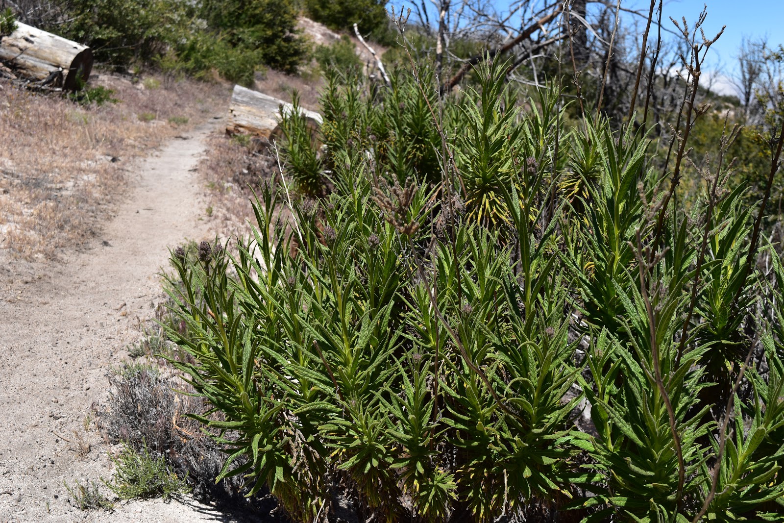
By the time I left Mill Creek the cloud layer was completely gone. I kind of wished it was back after a while, since I was walking in an exposed desert environment again. Thankfully, the trail soon became shaded again and continued on like this for quite some time. Eventually, I made my way back into a burned section again where the low vegetation was starting to overgrow the trail. It was so overgrown in spots that I ended up bushwhacking at times. I had to use my poles to push the vegetation out of the way to see where the trail was. As some added fun, I occasionally got a whiff of skunky weed, which meant that there was poodle dog bush mixed into the green wall I was trying to walk through.
Leaving Mill Creek.
Bonus hummingbird outside of Mill Creek.
Hello, I am a stinky poodle dog bush. Don't forget that I am still here.
Oh, California. Celebrating mile 420 amid the skunky weed smell from the poodle dog bushes.
Shade along the PCT!
The vegetation starting to overgrow the trail.
I refilled my water once again at a stream (that could barely be called a stream) and ended my day waking uphill again, gaining all that elevation back. There was another burn area (slightly more recent than the current burn area) coming up where the trail was open, but camping was only allowed in one specific spot. I was going to camp just outside this semi-restricted burn area, then go through that section in a single day.
The campground I wanted to go to was called Messenger Flats and it was just on the other side of Mt. Gleason. Unfortunately I had to get near the top of this mountain before crossing over, which took way more effort than it should have by this time in my hiking journey.
Hey, tired hiker. No time to relax, I'm still here and growing strong.
When I crossed over, I was rewarded with beautiful views of the surrounding mountains as well as a view of the desert area I would be heading into in the next couple of days. With these views also came wind.
Gorgeous, high-elevation views.
Coming down Mt. Gleason with the desert looming below.
The closer I got to the campground, the stronger the wind got. There were two other tents already set up, but no sign of the people. I knew the yellow tent belonged to Kevin and Hanna and I assumed the other tent belonged to another hiker I met named Monk, who was hiking in a hiking kilt (the second one I have seen on the trail), using sticks he found in the woods as hiking poles. They were already hunkered down in their tents to avoid the strong, cold wind.
While they had set up their tents right near the trail, I walked around the area to look for the best spot. The winds were blowing the grass straight down through that entire campground. I found a place down a hill, in some trees, and sheltered by a picnic table and I was still getting strong gusts of wind. Hopefully that will die down tonight. It have a feeling it will be another cold one.
The best spot I could find to shelter from the wind.
20.3 miles Just like the past few mornings, it was difficult to get up again. Unlike the past few mornings, I could actually see snow on top of my tent. It was supposed to rain or snow on and off the majority of the day again. That was not a motivating thought to get me out of my sleeping bag. I had also finally used the hand warmers that I had purchased back in Flagstaff, and they were still warm inside my bag. Somehow, I emerged from that bag and packed everything up one last time. I was only about 20 miles from the Utah border and on schedule to finish the trail today. Most of the items I had on me were damp or wet. It didn’t bother me packing them up as I knew I would be warm and dry tonight. What did bother me was having to put on my wet, cold, dirty shoes. After I did that, I had wet, cold, dirty socks as well. In Flagstaff I had also picked up toe warmers, so I stuck those inside my shoes and hoped that they would help. The view looking out of my tent. My camps...
26.6 FT miles I had meant to get up really early this morning. There were only two places in the St Marks National Wildlife Refuge where you could camp, and there was one that was supposedly one of the best, if not the best, campsite on the trail. However, it was over 26 miles away. Some of those miles were going to be road walks, so those parts would go quickly. On the other hand, if we encountered swampy areas, it might be a very long day. A little before dawn I yelled over at Sugar Rush to see if she was awake, which she was. We packed up in the dark and, just like last night, went crashing through the brush trying to stay on trail. There were some parts that were clear and other parts that were not so clear. When the sun came up, things didn't necessarily get better. We started to realize why we were having so much trouble last night. Even with daylight we couldn't always track the path on the ground and had to search as a team for hidden blazes. The river made...
27.1 miles I tried looking at what the day had in store for my on the Arizona Trail app. Pretty much the only things labeled were forest roads, trail junctions, and stock tanks. Nothing too exciting. The morning turned out mostly as described. I left the tank I camped at last night on a forest road, then joined another forest road, then a footpath for a short while, then another forest road. Hiking a forest road. The signs could have been a little better in this section. I had to keep looking at my app to make sure I knew where to turn. After a while the signage got better and I turned onto another footpath. A footpath section of trail. I was heading to a spring I wanted to use as a water source. When I checked the app, it showed me off trail. I knew I couldn't have been off trail because I turned at a very clear “Arizona Trail” sign. On the app, the trail followed forest roads. I figured the footpath must be new and the app hadn't been updated...


Comments
Post a Comment